




Look-Angle Optimization for Ocean Surface Current Vector Observation Using Dual-Beam Along-Track Interferometric SAR
-
摘要: 本文针对星载双波束顺轨干涉合成孔径雷达(dual-beam along-track interferometric synthetic aperture radar, DBATI-SAR)海面流场矢量观测中投影几何增益与干涉测速性能退化的相互制约关系,研究了下视角优化设计问题。基于双波束径向速度投影与线性协方差传播,构建贯通星地几何、海面散射、系统噪声等效后向散射系数、信噪比、干涉相干性、ATI相位噪声及二维流速反演的随机误差模型,并以误差协方差矩阵最大特征值的平方根表征二维随机测流误差。在正交投影和前、后视通道近似对称条件下,推导二维随机测流误差关于下视角的紧凑表达式,揭示内部最优下视角的形成机理。结果表明,增大下视角能够增强雷达视线方向的水平投影并减弱几何误差放大,但斜距和局部入射角随之增大,导致海面后向散射减弱以及信噪比和相干性退化。本文仿真了不同噪声等效后向散射系数(noise equivalent sigma zero, NESZ)、风速、轨道高度和基线长度等关键参数下的最优下视角,综合考虑各类代表性参数变化范围,得到多工况推荐下视角范围为25.75°~31.00°,可为星载DBATI-SAR观测几何与系统灵敏度的协同设计提供参考。Abstract:
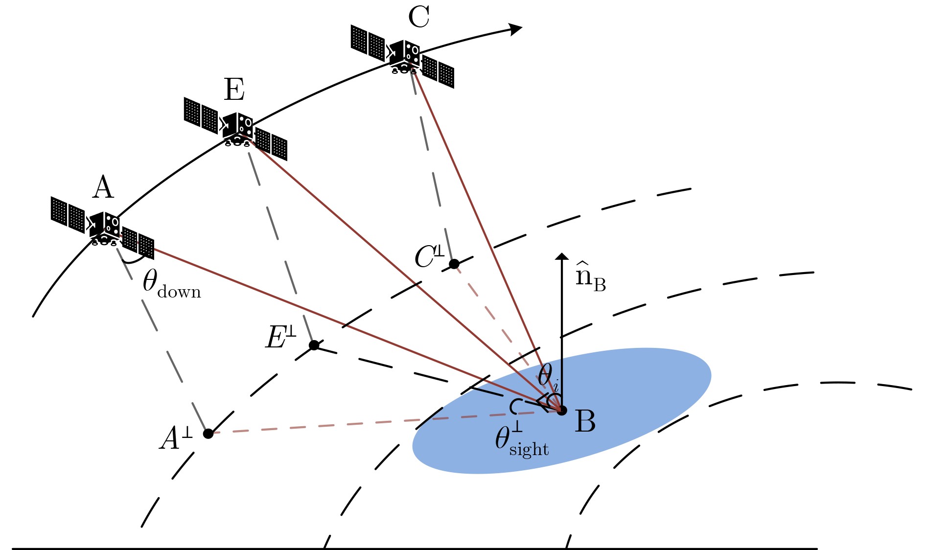
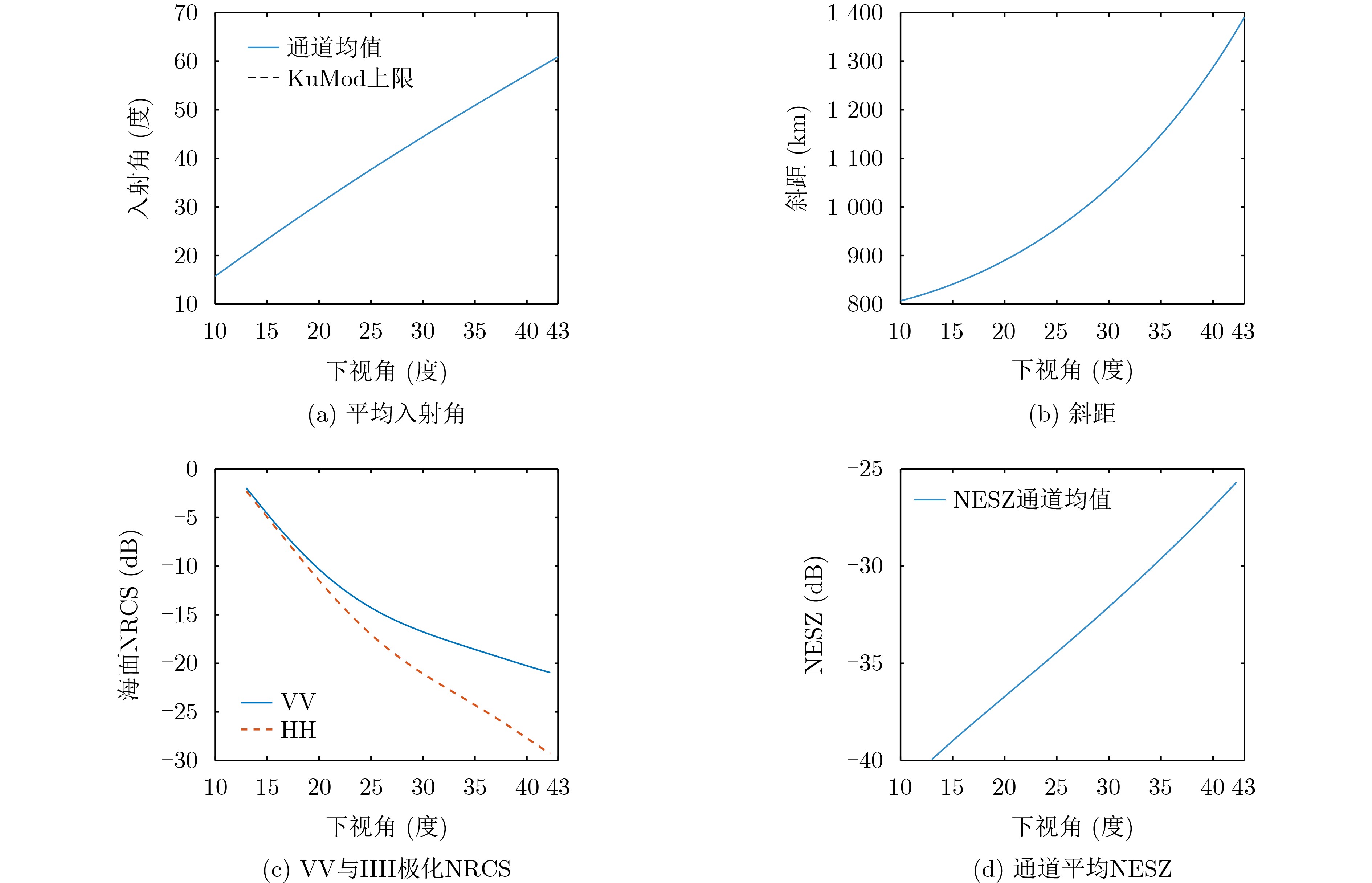
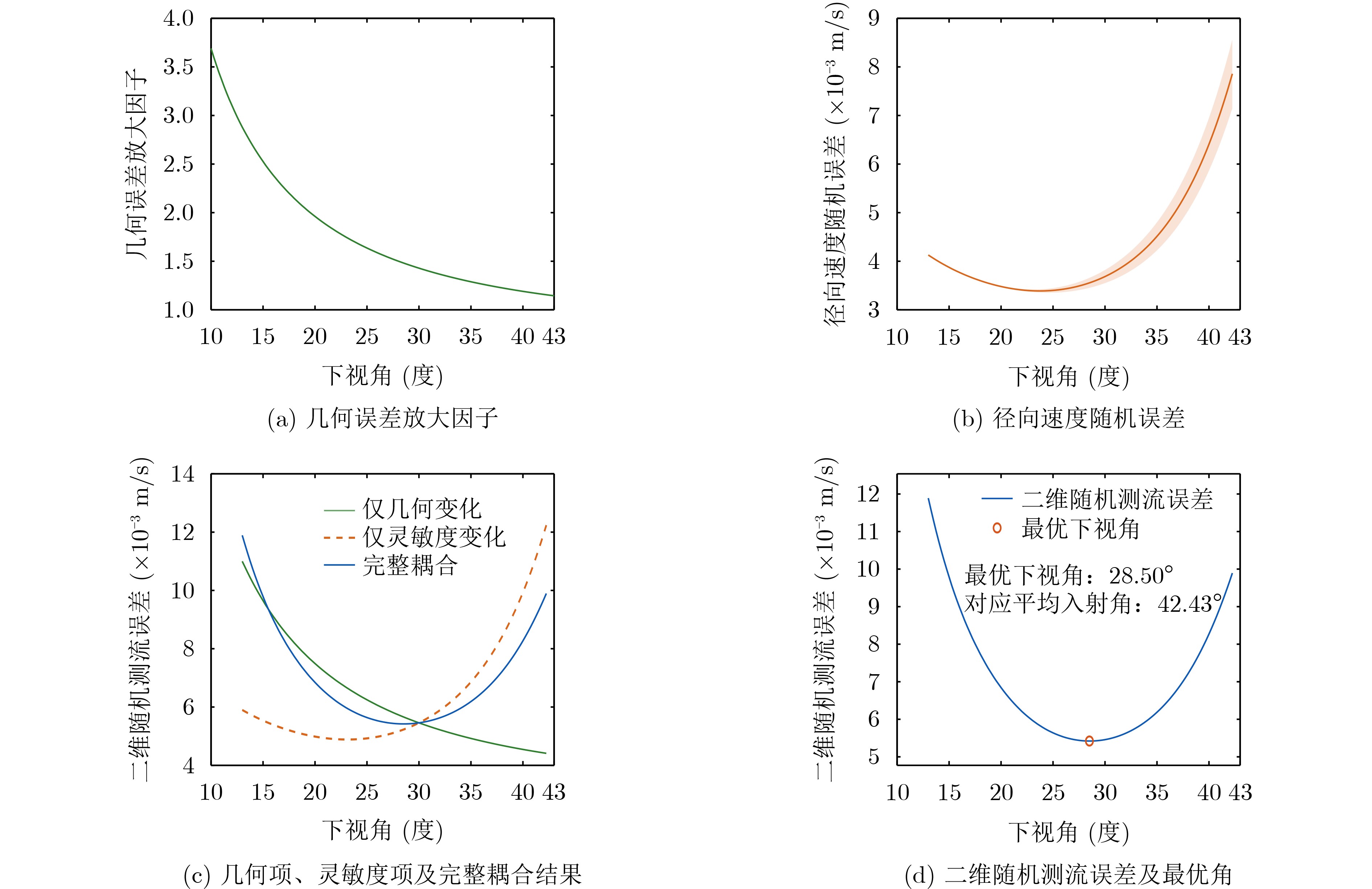
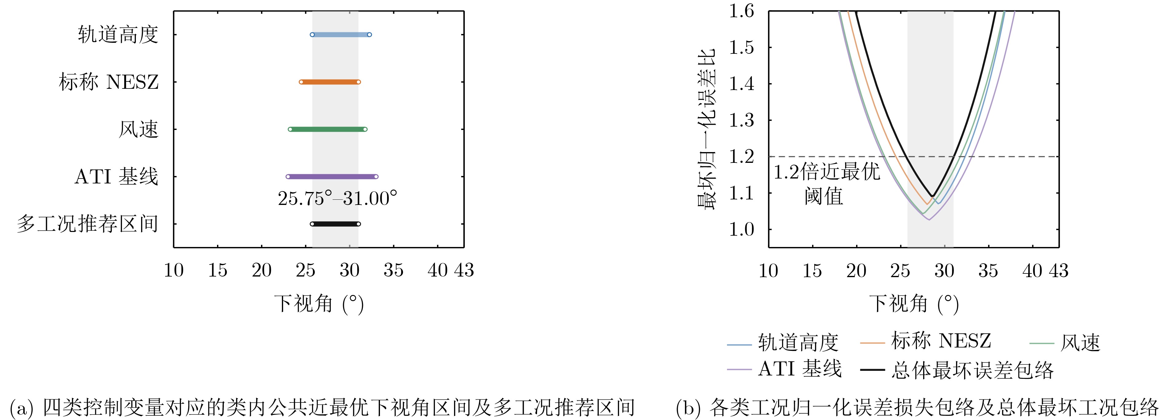
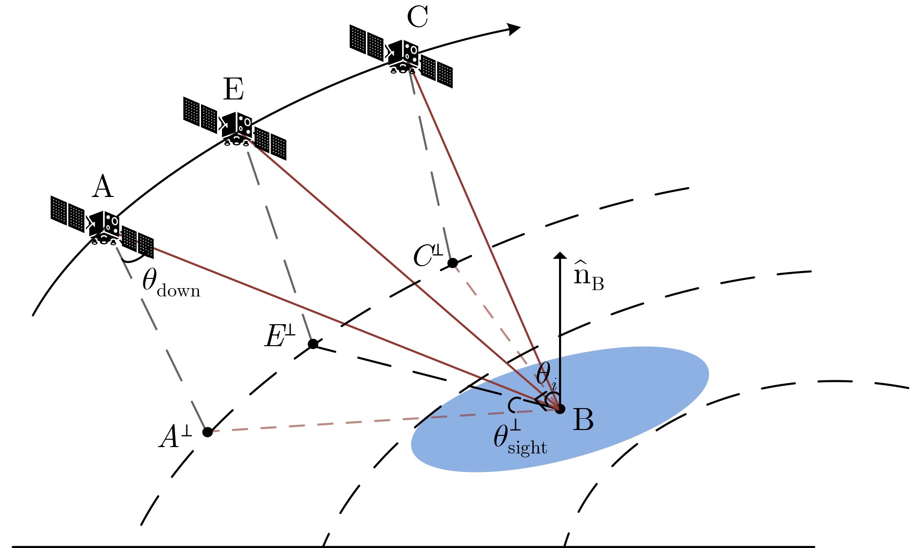
Objective Spaceborne dual-beam along-track interferometric synthetic aperture radar (DBATI-SAR) acquires fore- and aft-looking radial velocities along different ground-projected radar line-of-sight (RLOS) directions, providing the directional diversity required for two-dimensional ocean surface current vector retrieval. The look angle is a key geometric design parameter because it affects both the horizontal RLOS projection and the interferometric radial-velocity accuracy. Increasing the look angle generally increases the local incidence angle, thereby strengthening the horizontal RLOS projection and reducing geometric error amplification. Meanwhile, the associated increases in slant range and incidence angle weaken ocean-surface backscatter and degrade the signal-to-noise ratio (SNR) and interferometric coherence. This study investigates this tradeoff and determines an appropriate look-angle range for spaceborne DBATI-SAR current-vector measurements. Methods A unified random-error model is developed by integrating dual-beam radial-velocity projection, linear covariance propagation, spaceborne observation geometry, normalized radar cross section (NRCS), noise-equivalent sigma zero (NESZ), SNR, interferometric coherence, effective number of looks, ATI phase noise, and phase-to-velocity conversion. The square root of the maximum eigenvalue of the two-dimensional velocity-error covariance matrix is adopted as the two-dimensional random current-retrieval error metric. Under orthogonal ground-projected RLOS geometry and approximately symmetric fore- and aft-looking channels, a compact analytical expression is derived to characterize the competition between geometric error reduction and radial-velocity error growth. Numerical simulations employ a Ku-band reference configuration while retaining the actual incidence angle, slant range, NRCS, NESZ, SNR, and radial-velocity error of each channel. Orbit altitude, nominal NESZ, ocean wind speed, and ATI baseline are further varied to examine their effects on the optimum look angle. A near-optimal interval is defined by requiring the error under each operating condition not to exceed 1.2 times its corresponding minimum. Results and Discussions The results confirm the competing effects of the look angle on projection geometry and interferometric velocity accuracy. As the look angle increases, both the mean incidence angle and slant range increase, whereas ocean-surface NRCS decreases and NESZ increases, resulting in progressive SNR degradation at large look angles ( Fig. 3 ). The geometric error amplification factor decreases monotonically, whereas the radial-velocity error increases rapidly at large angles; their combined effect therefore produces an interior optimum (Fig. 4 ). Under the reference configuration, the minimum two-dimensional random current error is0.0054 m/s at a look angle of 28.50°, corresponding to a mean incidence angle of 42.43°. Increasing the orbit altitude from 500 to1000 km shifts the optimum look angle from 34.75° to 25.00°, while degrading the nominal NESZ from –35 to –25 dB shifts it from 33.00° to 24.00°. Increasing the wind speed from 4 to 12 m/s shifts the optimum from 24.25° to 31.25°, whereas increasing the ATI baseline from 4 to 20 m shifts it from 25.50° to 31.25° (Fig. 5 ). The intersection of the near-optimal intervals for all representative conditions yields a recommended look-angle range of 25.75°–31.00°, within which the worst-case normalized error does not exceed 1.2 (Fig. 6 ).Conclusions The optimum look angle for spaceborne DBATI-SAR is governed by the tradeoff between reduced geometric error amplification and degraded radial-velocity accuracy at large angles. The proposed error framework quantitatively links observation geometry, system sensitivity, and ocean-surface scattering. The resulting look-angle range of 25.75°–31.00° provides a practical reference for the joint design of observation geometry and system sensitivity for spaceborne DBATI-SAR ocean surface current vector measurements. -
表 1 基准计算参数
参数 取值 单位 说明 工作频率/轨道高度 13.5/780 GHz, km — 卫星端下视角/KuMod有效入射角 10~43/20~60 ° 搜索步长0.25°;后者仅限定NRCS计算域 海面风速/风向/极化 8/0/VV m/s, °, - HH仅用于图3(c)对照 ATI物理基线/海面等效相关时间 12/4.5 m, ms 高斯型时间去相关模型 残余相干系数 0.98 - 包含通道与处理残差 距离向带宽/方位向单视分辨率 150/20 MHz, m — 流场产品分辨率/有效视数折减系数 1000/0.90 m, - — 噪声系数/参考噪声温度/处理损失 3.0/290/3.8 dB, K, dB 处理损失含距离向、方位向、量化与实现损失 脉宽/PRF/占空比 35/ 5100 /0.1785 μs, Hz, - 基准平均发射功率11.164 kW  下载: 导出CSV
表 2 控制变量取值与实施方式
变量 5组取值 控制变量设置 轨道高度 500, 625, 780, 875, 1000 km固定雷达硬件与平均发射功率, 重新计算星地几何和传播损耗 标称NESZ –35, –32.5, –30, –27.5, –25 dB 在定义点通过调整平均发射功率实现 海面风速 4, 6, 8, 10, 12 m/s 仅通过KuMod更新海面NRCS ATI物理基线 4, 8, 12, 16, 20 m 同步更新相位—速度灵敏度和时间去相关
下载: 导出CSV
-
[1] LÉVY M, COUESPEL D, HAËCK C, et al. The impact of fine-scale currents on biogeochemical cycles in a changing ocean[J]. Annual Review of Marine Science, 2024, 16: 191–215. doi: 10.1146/annurev-marine-020723-020531. [2] MCWILLIAMS J C. Submesoscale currents in the ocean[J]. Proceedings of the Royal Society A: Mathematical, Physical and Engineering Sciences, 2016, 472(2189): 20160117. doi: 10.1098/rspa.2016.0117. [3] CAO Yuhan, DONG Changming, STEGNER A, et al. Global sea surface cyclogeostrophic currents derived from satellite altimetry data[J]. Journal of Geophysical Research: Oceans, 2023, 128(1): e2022JC019357. doi: 10.1029/2022JC019357. [4] MORROW R, FU L L, ARDHUIN F, et al. Global observations of fine-scale ocean surface topography with the surface water and ocean topography (SWOT) mission[J]. Frontiers in Marine Science, 2019, 6: 232. doi: 10.3389/fmars.2019.00232. [5] PADUAN J D and WASHBURN L. High-frequency radar observations of ocean surface currents[J]. Annual Review of Marine Science, 2013, 5: 115–136. doi: 10.1146/annurev-marine-121211-172315. [6] 吴一凡, 黄丽佳, 严朝保, 等. 面向GEO SAR图像的海上区域运动目标检测方法[J]. 电子与信息学报, 2025, 47(6): 1723–1733. doi: 10.11999/JEIT240906.WU Yifan, HUANG Lijia, YAN Chaobao, et al. A moving target detection method for GEO SAR image in maritime areas[J]. Journal of Electronics & Information Technology, 2025, 47(6): 1723–1733. doi: 10.11999/JEIT240906. [7] 刘昆, 贺雄鹏, 廖桂生, 等. 面向复杂场景的多通道慢速动目标稳健检测算法[J]. 电子与信息学报, 2024, 46(5): 2018–2027. doi: 10.11999/JEIT230958.LIU Kun, HE Xiongpeng, LIAO Guisheng, et al. A robust multi-channel moving target detection algorithm for complex scenes[J]. Journal of Electronics & Information Technology, 2024, 46(5): 2018–2027. doi: 10.11999/JEIT230958. [8] 焦润之, 邓嘉, 韩亚权, 等. 3DSARBuSim 1.0: 人造建筑高分辨星载SAR三维成像仿真数据集[J]. 电子与信息学报, 2024, 46(7): 2681–2693. doi: 10.11999/JEIT230882.JIAO Runzhi, DENG Jia, HAN Yaquan, et al. 3DSARBuSim 1.0: High-resolution space borne SAR 3D imaging simulation dataset of man-made buildings[J]. Journal of Electronics & Information Technology, 2024, 46(7): 2681–2693. doi: 10.11999/JEIT230882. [9] 何奇山, 赵凌君, 计科峰, 等. 面向SAR目标识别成像参数敏感性的深度学习技术研究进展[J]. 电子与信息学报, 2024, 46(10): 3827–3848. doi: 10.11999/JEIT240155.HE Qishan, ZHAO Lingjun, JI Kefeng, et al. Research progress of deep learning technology for imaging parameter sensitivity of SAR target recognition[J]. Journal of Electronics & Information Technology, 2024, 46(10): 3827–3848. doi: 10.11999/JEIT240155. [10] MOISEEV A, JOHNSEN H, JOHANNESSEN J A, et al. On removal of sea state contribution to Sentinel-1 Doppler shift for retrieving reliable ocean surface current[J]. Journal of Geophysical Research: Oceans, 2020, 125(9): e2020JC016288. doi: 10.1029/2020JC016288. [11] MARTIN A C H, GOMMENGINGER C P, JACOB B, et al. First multi-year assessment of Sentinel-1 radial velocity products using HF radar currents in a coastal environment[J]. Remote Sensing of Environment, 2022, 268: 112758. doi: 10.1016/j.rse.2021.112758. [12] GOLDSTEIN R M and ZEBKER H A. Interferometric radar measurement of ocean surface currents[J]. Nature, 1987, 328(6132): 707–709. doi: 10.1038/328707a0. [13] ROMEISER R and THOMPSON D R. Numerical study on the along-track interferometric radar imaging mechanism of oceanic surface currents[J]. IEEE Transactions on Geoscience and Remote Sensing, 2000, 38(1): 446–458. doi: 10.1109/36.823940. [14] ROMEISER R, SUCHANDT S, RUNGE H, et al. First analysis of TerraSAR-X along-track InSAR-derived current fields[J]. IEEE Transactions on Geoscience and Remote Sensing, 2010, 48(2): 820–829. doi: 10.1109/TGRS.2009.2030885. [15] PAN Bo, YUAN Xinzhe, LI Tao, et al. First retrieval of sea surface currents using L-band SAR in satellite formation[J]. Remote Sensing, 2025, 17(1): 131. doi: 10.3390/rs17010131. [16] LIU Genwang, ZHANG Rui, CAO Chenghui, et al. Radial velocity inversion and accuracy assessment of ocean surface current based on GF-3 SAR[J]. Journal of Applied Remote Sensing, 2025, 19(3): 032004. doi: 10.1117/1.JRS.19.032004. [17] WANG Lihua, TAN Benhua, CHU Xiaoqing, et al. Correction and validation of Sentinel-1 IW radial velocity products using drifter and HF radar across the entire ocean environment[J]. Remote Sensing of Environment, 2025, 328: 114909. doi: 10.1016/j.rse.2025.114909. [18] FRASIER S J and CAMPS A J. Dual-beam interferometry for ocean surface current vector mapping[J]. IEEE Transactions on Geoscience and Remote Sensing, 2001, 39(2): 401–414. doi: 10.1109/36.905248. [19] TOPORKOV J V, PERKOVIC D, FARQUHARSON G, et al. Sea surface velocity vector retrieval using dual-beam interferometry: First demonstration[J]. IEEE Transactions on Geoscience and Remote Sensing, 2005, 43(11): 2494–2502. doi: 10.1109/TGRS.2005.848603. [20] MARTIN A C H, GOMMENGINGER C, MARQUEZ J, et al. Wind-wave-induced velocity in ATI SAR ocean surface currents: First experimental evidence from an airborne campaign[J]. Journal of Geophysical Research: Oceans, 2016, 121(3): 1640–1653. doi: 10.1002/2015JC011459. [21] MARTIN A C H, GOMMENGINGER C P, and QUILFEN Y. Simultaneous ocean surface current and wind vectors retrieval with squinted SAR interferometry: Geophysical inversion and performance assessment[J]. Remote Sensing of Environment, 2018, 216: 798–808. doi: 10.1016/j.rse.2018.06.013. [22] European Space Agency. Earth explorer 11 candidate mission seastar report for assessment[R]. ESA-EOPSM-SEAS-RP-4374, 2023. [23] MARTIN A C H, GOMMENGINGER C P, ANDRIEVSKAIA D, et al. Performance of the Earth Explorer 11 SeaSTAR mission candidate for simultaneous retrieval of total surface current and wind vectors[J]. Remote Sensing, 2024, 16(19): 3556. doi: 10.3390/rs16193556. [24] MCCANN D L, MARTIN A C H, DE MACEDO K A C, et al. A new airborne system for simultaneous high-resolution ocean vector current and wind mapping: First demonstration of the SeaSTAR mission concept in the macrotidal Iroise Sea[J]. Ocean Science, 2024, 20(5): 1109–1122. doi: 10.5194/os-20-1109-2024. [25] 范黄江, 张庆君, 刘磊, 等. 一种双星分布式干涉SAR流场测量的基线设计方法[J/OL]. 雷达学报(中英文), https://link.cnki.net/urlid/10.1030.TN.20260617.1832.002, 2026. doi: 10.12000/JR26065.FAN Huangjiang, ZHANG Qingjun, LIU Lei, et al. A baseline design method for interferometric SAR ocean current measurements using a dual-satellite distributed system[J/OL]. Journal of Radars, https://link.cnki.net/urlid/10.1030.TN.20260617.1832.002, 2026. doi: 10.12000/JR26065. [26] 申清源, 张洋洋, 赖涛, 等. 星载非对称几何下双波束顺轨干涉SAR关键几何参数求解方法[J/OL]. 电子与信息学报, https://link.cnki.net/urlid/11.4494.TN.20260910.1705.002, 2026.SHEN Qingyuan, ZHANG Yangyang, LAI Tao, et al. Determination of key geometric parameters for spaceborne dual-beam along-track interferometric SAR under asymmetric geometry[J/OL]. Journal of Electronics & Information Technology, https://link.cnki.net/urlid/11.4494.TN.20260910.1705.002, 2026. [27] WENTZ F J and SMITH D K. A model function for the ocean-normalized radar cross section at 14 GHz derived from NSCAT observations[J]. Journal of Geophysical Research: Oceans, 1999, 104(C5): 11499–11514. doi: 10.1029/98JC02148. -

 下载:



图(6) / 表(2)
计量
- 文章访问数: 13
- HTML全文浏览量: 1
- PDF下载量: 0
- 被引次数: 0
