




Determination of Key Geometric Parameters for Spaceborne Dual-Beam Along-Track Interferometric SAR under Asymmetric Geometry
-
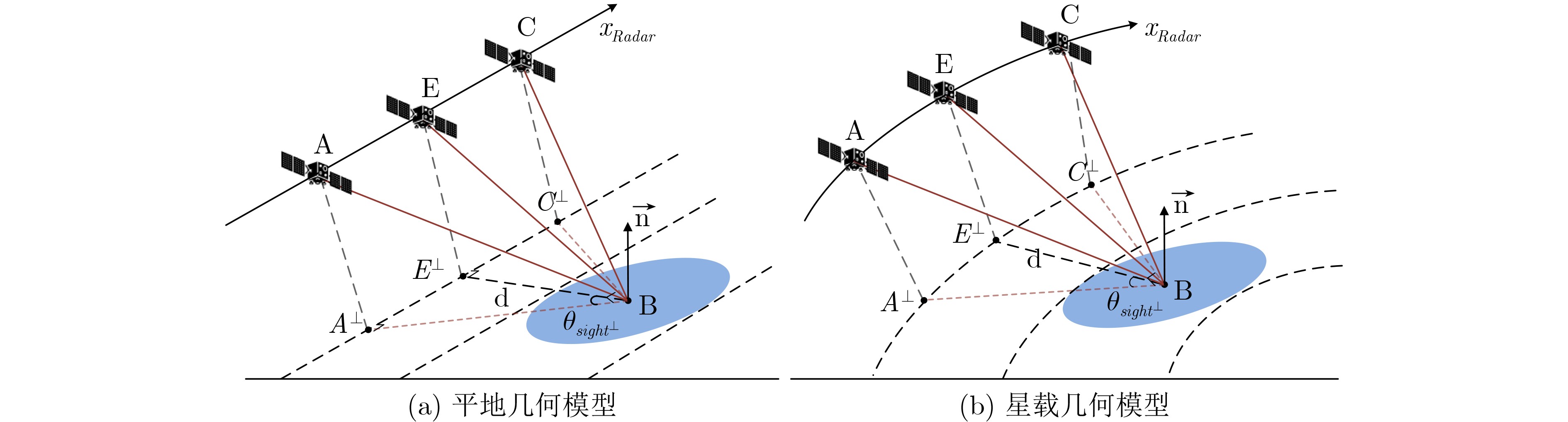
摘要: 星载双波束顺轨干涉合成孔径雷达(Dual-Beam Along-Track Interferometric Synthetic Aperture Radar, DBATI-SAR)可通过前、后视观测获取不同方向的海表径向速度,为二维海面流场矢量反演提供观测基础。二维流速反演的稳定性与两次雷达视线(Radar Line-of-Sight, RLOS)在目标点局部地表切平面内的投影关系密切相关,当前、后视RLOS地表投影接近正交时,径向速度误差向水平流速分量的几何放大较小。然而,传统前、后视几何参数求解多基于平地几何和匀速直线运动假设,难以刻画轨道曲率、地球曲率和地球自转共同作用下的星载非对称几何,易导致实际RLOS地表投影偏离理想正交构型。针对该问题,本文提出一种星载非对称几何下DBATI-SAR关键几何参数求解方法,以RLOS地表投影正交性作为直接约束。首先,在地心地固坐标系(Earth-Centered Earth-Fixed, ECEF)下建立星载观测几何模型,定义RLOS地表投影夹角、斜视角和下视角,并将观测时间、斜视角和下视角等关键几何参数的求解表述为满足RLOS地表投影正交约束的观测时间反问题。其次,在零斜视参考点邻域内推导观测时间偏置关于RLOS地表投影夹角的解析主项,用于解释观测时间尺度及主要几何控制因素。最后,基于完整ECEF正向几何采样构建多项式数值逆映射模型,实现给定投影夹角条件下关键几何参数的高精度求解。仿真结果表明,当采用 7 阶多项式且采样点数量不少于 20 时,500组随机轨道参数下的RLOS地表投影夹角平均误差约为0.04°;相比传统平地几何模型约 6.5° 的正交误差,几何约束精度显著提高,对应归一化几何放大因子由约 1.12 降至
1.0007 。所提方法可在完整星载非对称几何下实现前、后视观测时间、斜视角和下视角等关键几何参数的高精度求解。-
关键词:
- 星载DBATI-SAR /
- 非对称几何 /
- RLOS地表投影 /
- 数值逆映射
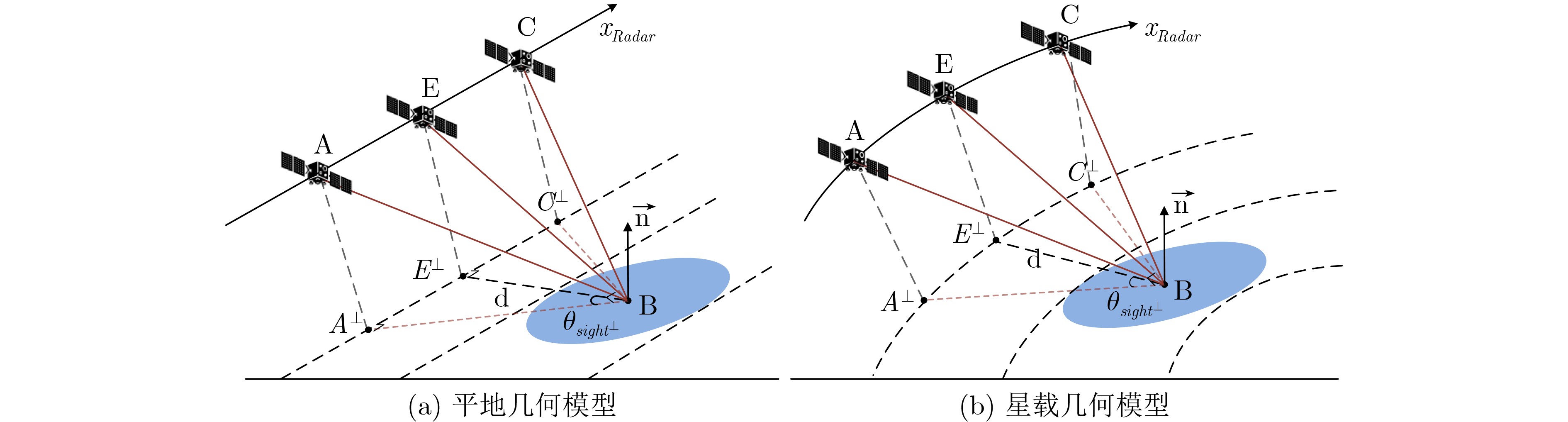
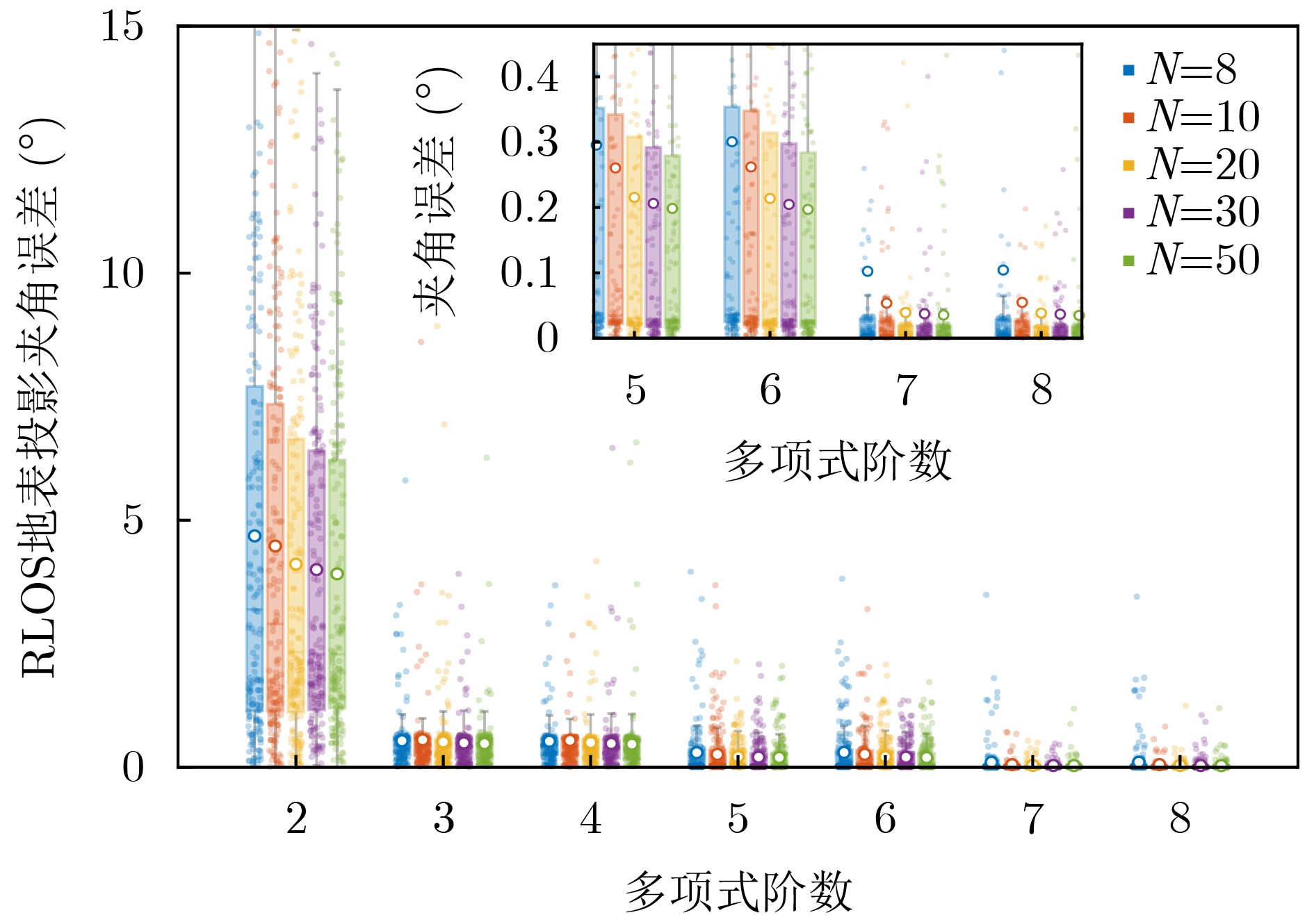
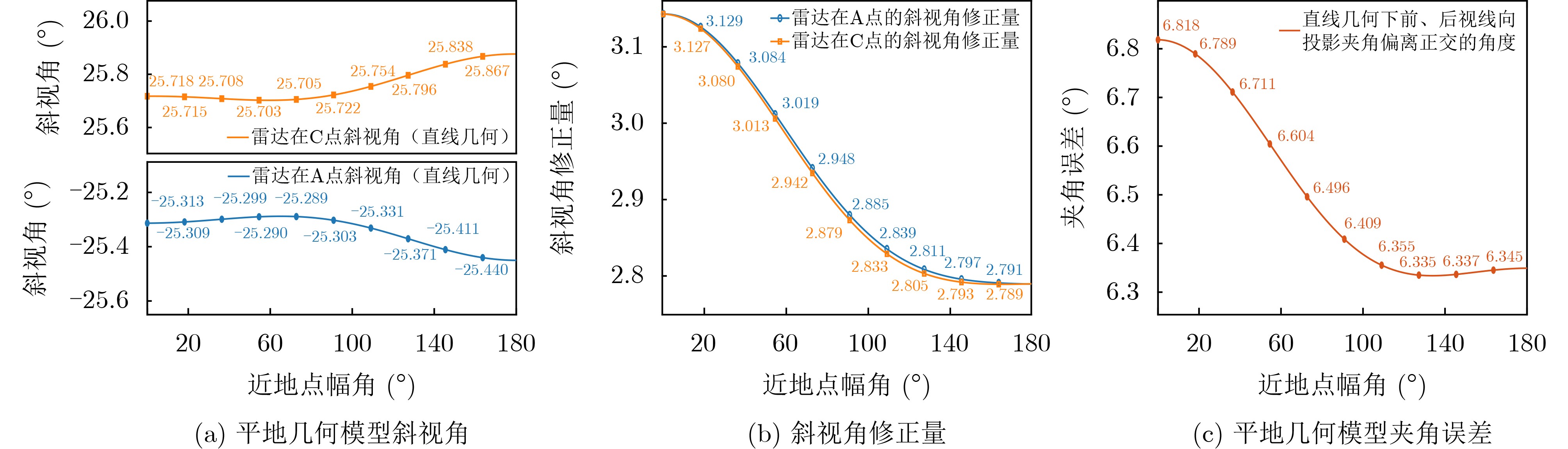
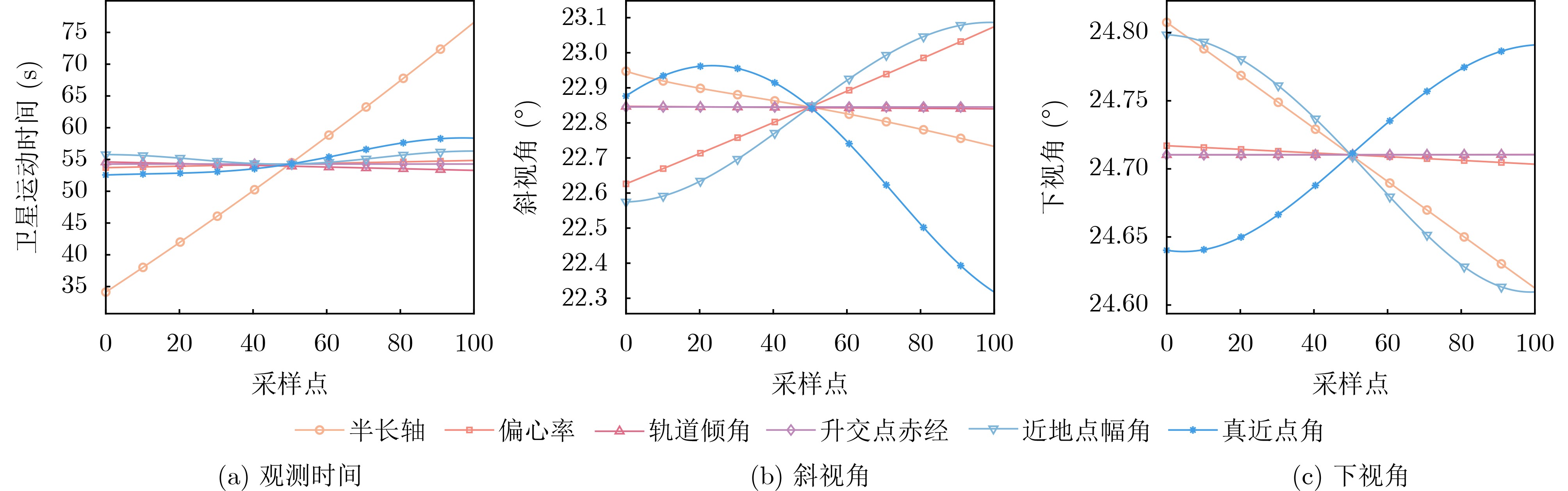
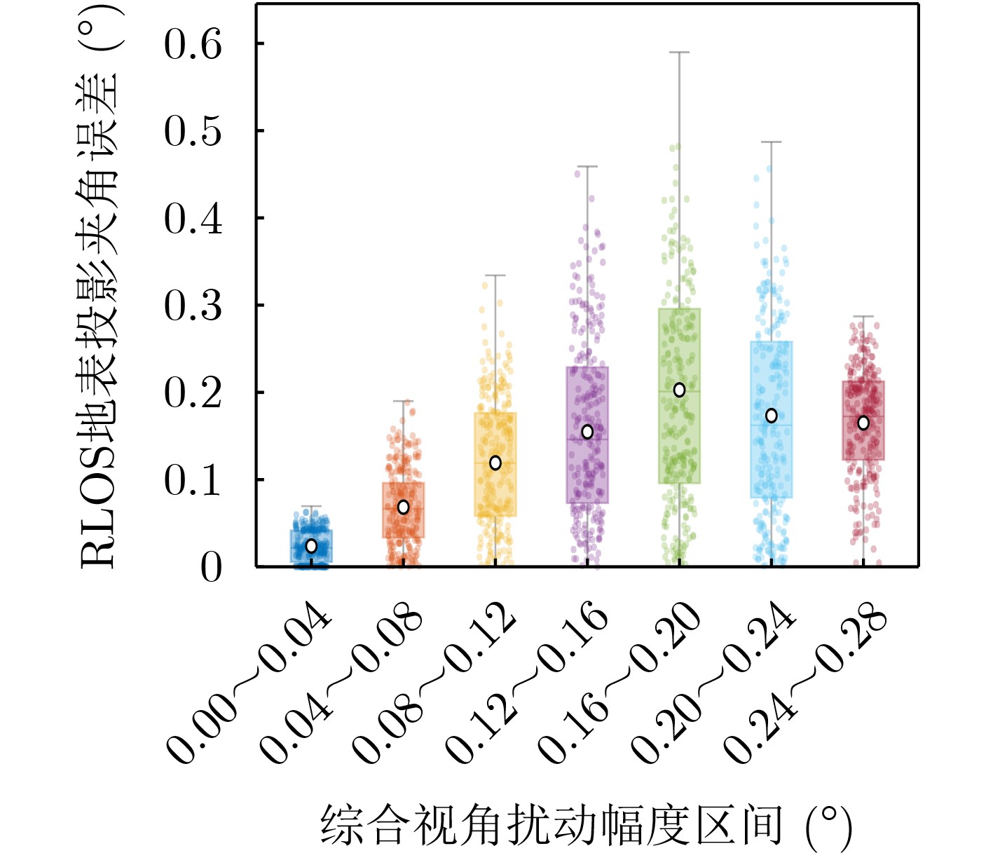
Abstract:Objective Spaceborne dual-beam along-track interferometric synthetic aperture radar (DBATI-SAR) acquires fore- and aft-looking radial velocities for two-dimensional ocean surface current retrieval. The inversion stability depends on the relative directions of the two radar line-of-sight (RLOS) projections on the target local tangent plane. Conventional flat-Earth models usually assume symmetric squint angles or time offsets, whereas orbital curvature, Earth curvature, Earth rotation, and local projection nonlinearity produce asymmetric spaceborne geometries. Consequently, symmetric squint angles do not necessarily guarantee orthogonal ground-projected RLOS directions. This study develops a method for determining the fore- and aft-looking observation times, squint angles, and look angles directly under the ground-projected RLOS orthogonality constraint. Methods A complete Earth-Centered Earth-Fixed (ECEF) geometry is established using the satellite state and target position. The RLOS is projected onto the target local tangent plane, and a signed ground-projected RLOS angle is defined relative to the zero-squint reference direction. The squint and look angles are calculated from the observation times rather than prescribed independently. A two-dimensional observation matrix is constructed between the horizontal current components and the two radial velocities. Under an ideal symmetric geometry adopted to simplify the derivation, the singular values and condition number show that a one-sided projection angle of $ {45}^{{^{\circ}}} $ gives the best inversion conditioning. A normalized geometric amplification factor is introduced to quantify additional error amplification caused by nonorthogonal projections. Near the zero-squint reference point, a closed-form analytical leading term is derived between the observation-time offset and ground-projected RLOS angle. It reveals the effects of the reference slant range, look angle, equivalent along-track velocity, and second-order range-history curvature. A local polynomial inverse mapping is then constructed from complete ECEF forward-geometry samples. The target angles of $ {-45}^{{^{\circ}}} $ and $ +{45}^{{^{\circ}}} $ are inserted into the inverse mapping to obtain the fore- and aft-looking times, after which the corresponding squint and look angles are calculated. Results and Discussions Numerical experiments are conducted using 500 random orbit-parameter sets. Fifth- and sixth-order polynomials show relatively large inverse-mapping errors, whereas a seventh-order model significantly improves accuracy. With 20 samples, the mean ground-projected RLOS angle error is $ {0.0392}^{\circ } $, and further increases in polynomial order or sample number provide limited improvement ( Fig. 2 ,Table 2 ). The analytical leading term agrees well with the complete ECEF model. For a representative case, the angular root-mean-square error and maximum deviation are approximately $ {0.11}^{\circ } $ and $ {0.31}^{\circ } $, respectively. Across the 500 cases, the root-mean-square errors of the analytical fore- and aft-looking times are 0.95 s and 0.57 s, indicating that the analytical term captures the dominant time scale, while the numerical inverse mapping compensates for asymmetric higher-order effects (Fig. 3 ). The conventional flat-Earth model produces a squint-angle correction of up to approximately $ {3}^{\circ } $ and a projection orthogonality error of approximately $ {6.5}^{\circ } $. The proposed method reduces the mean angle error to approximately $ {0.04}^{\circ } $ and decreases the normalized geometric amplification factor from approximately 1.12 to1.0007 (Fig. 4 ). The semimajor axis has the strongest influence on the aft-looking time, which varies from approximately 34 s to 76 s, while variations caused by other orbital parameters remain within 7 s (Fig. 5 ). Under combined squint- and down-looking-angle perturbations of up to $ {0.2}^{\circ } $, most samples retain projection-angle errors below $ {1}^{\circ } $ (Fig. 6 ).Conclusions A key geometric parameter determination method is proposed for spaceborne DBATI-SAR under asymmetric geometry. The analytical leading term explains the dominant observation-time scale, while the complete ECEF numerical inverse mapping accurately determines the fore- and aft-looking observation times and corresponding viewing angles. The method provides substantially higher geometric accuracy than the conventional flat-Earth approach. Practical mission design should additionally consider pulse repetition frequency, azimuth ambiguity, Doppler bandwidth, beam-steering capability, and ATI coherence. -
表 1 参数取值范围
参数 取值范围 半长轴 (千米) 6 878~7 378 偏心率 0~0.01 轨道倾角 (度) 70~90 升交点赤经 (度) 0~180 近地点幅角 (度) 0~180 真近点角(度) 0~180 下视角(度) 20~60  下载: 导出CSV
表 2 不同阶数和采样点数下的平均RLOS 地表投影夹角误差(度)
N=8 N=10 N=20 N=30 N=50 Np=5 0.2955 0.2605 0.2154 0.2062 0.1985 Np=6 0.3006 0.2620 0.2138 0.2047 0.1971 Np=7 0.1024 0.0536 0.0392 0.0374 0.0355 Np=8 0.1043 0.0548 0.0385 0.0367 0.0348
下载: 导出CSV
-
[1] GOLDSTEIN R M and ZEBKER H A. Interferometric radar measurement of ocean surface currents[J]. Nature, 1987, 328(6132): 707–709. doi: 10.1038/328707a0. [2] CHAPRON B, COLLARD F, and ARDHUIN F. Direct measurements of ocean surface velocity from space: Interpretation and validation[J]. Journal of Geophysical Research: Oceans, 2005, 110(C7): C07008. doi: 10.1029/2004JC002809. [3] ROMEISER R and RUNGE H. Theoretical evaluation of several possible along-track InSAR modes of TerraSAR-X for ocean current measurements[J]. IEEE Transactions on Geoscience and Remote Sensing, 2007, 45(1): 21–35. doi: 10.1109/TGRS.2006.885405. [4] ROMEISER R, RUNGE H, SUCHANDT S, et al. Quality assessment of surface current fields from TerraSAR-X and TanDEM-X along-track interferometry and Doppler centroid analysis[J]. IEEE Transactions on Geoscience and Remote Sensing, 2014, 52(5): 2759–2772. doi: 10.1109/TGRS.2013.2265659. [5] WANG Lihua, TAN Benhua, CHU Xiaoqing, et al. Correction and validation of Sentinel-1 IW radial velocity products using drifter and HF radar across the entire ocean environment[J]. Remote Sensing of Environment, 2025, 328: 114909. doi: 10.1016/j.rse.2025.114909. [6] YUAN Xinzhe, LIN Mingsen, HAN Bing, et al. Observing sea surface current by Gaofen-3 satellite along-track interferometric SAR experimental mode[J]. IEEE Journal of Selected Topics in Applied Earth Observations and Remote Sensing, 2021, 14: 7762–7770. doi: 10.1109/JSTARS.2021.3099105. [7] DU Yanlei, SHAO Jianing, YANG Xiaofeng, et al. Investigation of current-wave interaction effect on ocean surface current retrieval under DCA framework using an improved Doppler radar imaging model[J]. IEEE Transactions on Geoscience and Remote Sensing, 2024, 62: 4213217. doi: 10.1109/TGRS.2024.3506952. [8] YANG Zhonghao, WANG Jing, LIU Lei, et al. Estimating effects of wind and waves on the Doppler centroid frequency shift for the SAR retrieval of ocean currents[J]. Remote Sensing of Environment, 2024, 311: 114312. doi: 10.1016/j.rse.2024.114312. [9] FAN Shengren, KUDRYAVTSEV V, YUROVSKY Y, et al. Reconstructing ocean surface current vector field from SAR Doppler shift measurements[J]. Remote Sensing of Environment, 2025, 328: 114855. doi: 10.1016/j.rse.2025.114855. [10] ZHAO Wenjia, ZHAO Yawei, XU Yongsheng, et al. Correction of non-geophysical errors in SAR Doppler shift for ocean surface current retrieval[J]. Earth and Space Science, 2026, 13(4): e2025EA004766. doi: 10.1029/2025EA004766. [11] WANG Lihua, TAN Benhua, CHU Xiaoqing, et al. Monitoring ocean surface current from Spaceborne SAR Doppler shift: Progress and perspective[J]. IEEE Geoscience and Remote Sensing Magazine, 2026, 14(3): 238–260. doi: 10.1109/MGRS.2026.3660703. [12] PAN Bo, WANG Zhibin, ZHANG Qingjun, et al. First simultaneous inversion of sea-surface velocity and height based on PIE-1 SAR constellation[J]. IEEE Transactions on Geoscience and Remote Sensing, 2025, 63: 5206118. doi: 10.1109/TGRS.2025.3544505. [13] GABRIELLI S, JONAS C, GUERRUCCI R, et al. Earth explorer 11 - SEASTAR phase 0[C]. EUSAR 2024; 15th European Conference on Synthetic Aperture Radar, Munich, Germany, 2024: 1017–1021. [14] MARTIN A C H, GOMMENGINGER C P, and QUILFEN Y. Simultaneous ocean surface current and wind vectors retrieval with squinted SAR interferometry: Geophysical inversion and performance assessment[J]. Remote Sensing of Environment, 2018, 216: 798–808. doi: 10.1016/j.rse.2018.06.013. [15] FRASIER S J and CAMPS A J. Dual-beam interferometry for ocean surface current vector mapping[J]. IEEE Transactions on Geoscience and Remote Sensing, 2001, 39(2): 401–414. doi: 10.1109/36.905248. [16] TOPORKOV J V, PERKOVIC D, FARQUHARSON G, et al. Sea surface velocity vector retrieval using dual-beam interferometry: First demonstration[J]. IEEE Transactions on Geoscience and Remote Sensing, 2005, 43(11): 2494–2502. doi: 10.1109/TGRS.2005.848603. [17] FARQUHARSON G, DENG Huazeng, GONCHARENKO Y, et al. Dual-beam ATI SAR measurements of surface currents in the nearshore ocean[C]. 2014 IEEE Geoscience and Remote Sensing Symposium, Quebec City, Canada, 2014: 2661–2664. doi: 10.1109/IGARSS.2014.6947021. [18] CALDARELLA N, LOPEZ-DEKKER P, PRATS-IRAOLA P, et al. Retrieval of wind and total surface current vectors using experimental bidirectional along-track interferometric TanDEM-X data[J]. IEEE Transactions on Geoscience and Remote Sensing, 2022, 60: 5223412. doi: 10.1109/TGRS.2022.3147490. [19] WOLLSTADT S, LÓPEZ-DEKKER P, DE ZAN F, et al. Design principles and considerations for spaceborne ATI SAR-based observations of ocean surface velocity vectors[J]. IEEE Transactions on Geoscience and Remote Sensing, 2017, 55(8): 4500–4519. doi: 10.1109/TGRS.2017.2692880. [20] FIEDLER H, BOERNER E, MITTERMAYER J, et al. Total zero Doppler steering-a new method for minimizing the Doppler centroid[J]. IEEE Geoscience and Remote Sensing Letters, 2005, 2(2): 141–145. doi: 10.1109/LGRS.2005.844591. [21] KAHLE R, KAZEMINEJAD B, KIRSCHNER M, et al. First in-orbit experience of TerraSAR-X flight dynamics operations[C]. The 20th International Symposium on Space Flight Dynamics, Annapolis, USA, 2007. [22] 王国华, 孙进平, 袁运能, 等. 星载合成孔径雷达系统偏航控制的精确计算[J]. 电子与信息学报, 2006, 28(9): 1569–1572.WANG Guohua, SUN Jinping, YUAN Yunneng, et al. Precise computation of yaw-steering in spaceborne synthetic aperture radar system[J]. Journal of Electronics & Information Technology, 2006, 28(9): 1569–1572. [23] 赵秉吉, 齐向阳, 宋红军, 等. 等效斜视距离模型在星载LEO-SAR中的精度分析[J]. 电子与信息学报, 2013, 35(1): 56–62. doi: 10.3724/SP.J.1146.2012.00647.ZHAO Bingji, QI Xiangyang, SONG Hongjun, et al. Analysis of effective slant range model accuracy based on Low-Earth-Orbital (LEO) spaceborne SAR[J]. Journal of Electronics & Information Technology, 2013, 35(1): 56–62. doi: 10.3724/SP.J.1146.2012.00647. [24] 田雨润, 禹卫东. 地球同步轨道SAR精确斜距模型研究[J]. 电子与信息学报, 2014, 36(8): 1960–1965. doi: 10.3724/SP.J.1146.2013.01478.TIAN Yurun and YU Weidong. Accurate slant range model analysis of geosynchronous SAR[J]. Journal of Electronics & Information Technology, 2014, 36(8): 1960–1965. doi: 10.3724/SP.J.1146.2013.01478. [25] JIAO Hongchen, LI Hailiang, ZHAO Liangbo, et al. Optimal estimation of Gaofen-3B satellite attitude deviation based on echo frequency domain features[J]. Acta Astronautica, 2023, 207: 54–61. doi: 10.1016/j.actaastro.2023.03.006. -

 下载:
下载:


图(6) / 表(2)
计量
- 文章访问数: 13
- HTML全文浏览量: 2
- PDF下载量: 1
- 被引次数: 0
