




Decision Learning Correction Network: Fusion Classification of Hyperspectral Images and LiDAR Data
-
摘要: 高光谱图像与激光雷达在光谱表征和空间结构刻画方面具有天然互补性,其有效融合被认为是提升遥感地物分类性能的重要途径。然而,现有方法多将融合过程建模为固定映射下的一次性静态聚合,隐含地假设同一融合策略能够适用于不同区域,因而难以应对遥感影像中普遍存在的空间异质性和样本复杂性。为此,该文提出一种决策-学习-修正网络,将传统静态融合重构为面向局部上下文的序列决策过程,使模型能够在连续交互中学习上下文依赖的自适应融合策略。针对关键样本易被忽视的问题,构建关键样本导向采样模块,依据样本决策困难度提高复杂区域样本的训练参与度。针对融合动作可能破坏模态特性的问题,设计模态保真约束机制,对不合理动作进行修正,以保证融合特征质量。实验结果表明,所提方法在Houston2013, Trento和MUUFL 3个基准数据集上的总体精度分别提升0.82%, 0.38%和1.76%,验证了该方法在复杂场景下的有效性与优越性。Abstract:
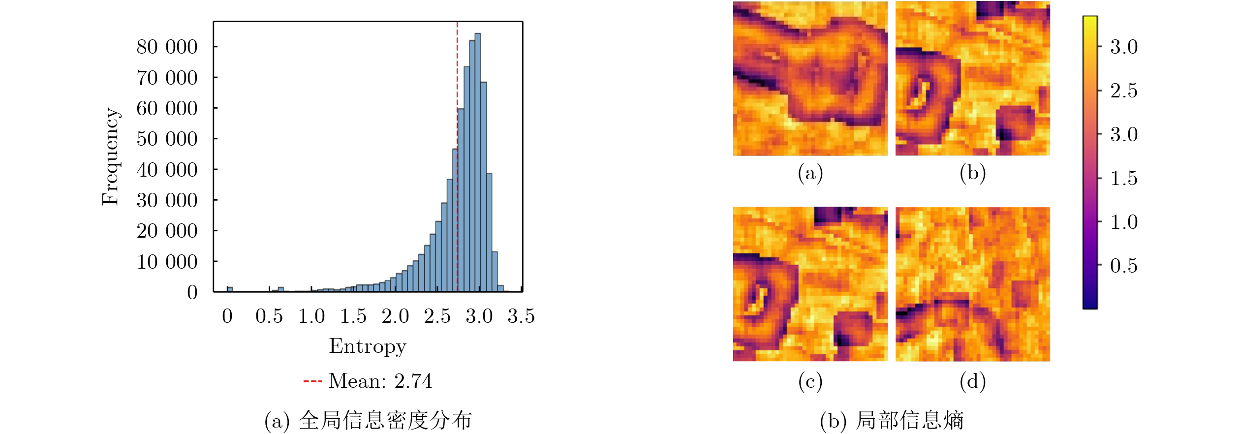
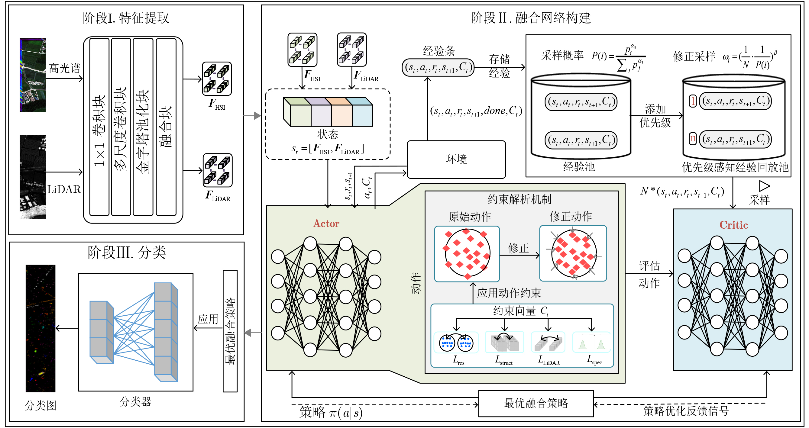
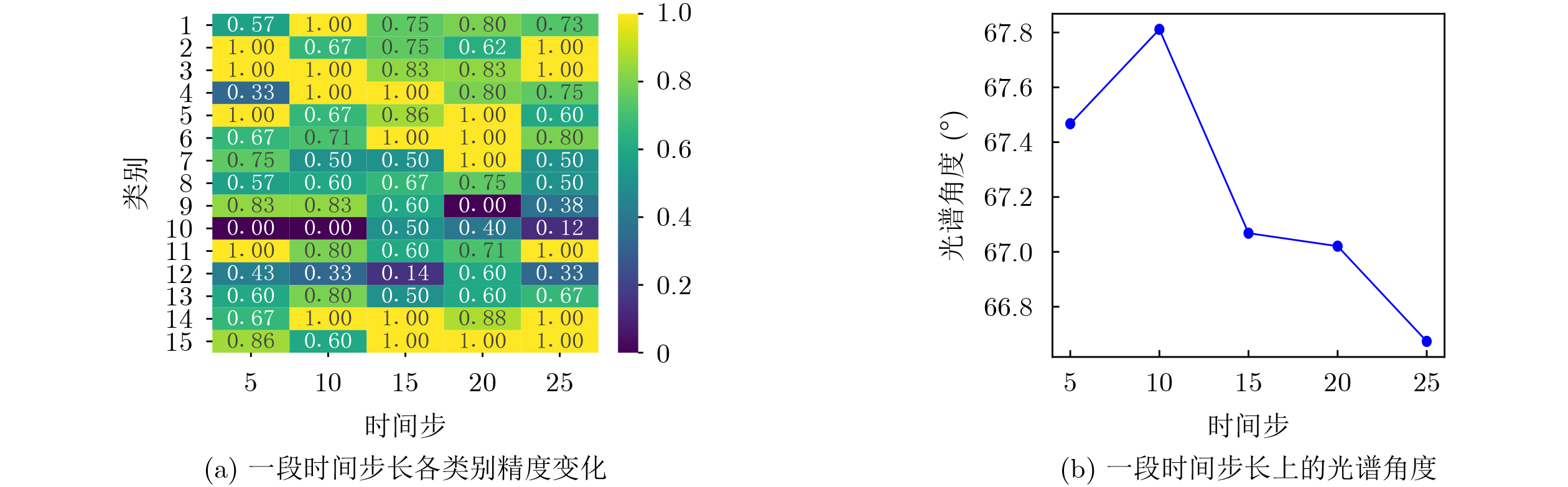
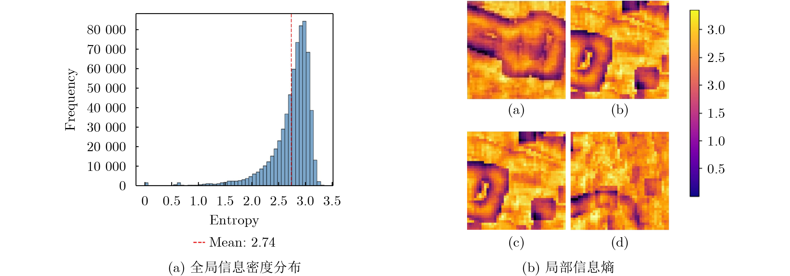
Objective HyperSpectral Images (HSI) and Light Detection And Ranging (LiDAR) provide complementary information for land-cover classification. HSI captures rich spectral information for material discrimination, while LiDAR provides elevation and structural information for spatial characterization. However, most existing fusion methods treat multimodal fusion as a one-shot static aggregation process, implicitly assuming that a fixed fusion strategy is applicable to all pixels and regions. This assumption is difficult to satisfy in complex remote sensing scenes, where class-boundary and cross-modal heterogeneous regions exhibit high information density but account for only a small proportion of samples ( Fig. 1 ). To address this limitation, this paper proposes a Decision Learning Correction Network (DLCN) that reformulates static HSI-LiDAR fusion as a context-dependent sequential decision-making process.Methods The proposed DLCN consists of feature extraction, fusion decision learning, and classification. First, HSI and LiDAR are processed through two parallel branches to extract spectral and spatial features and elevation and structural features, respectively. The extracted features are then concatenated to form the current state and are fed into an Actor-Critic framework. The Actor network generates fusion actions to adaptively adjust modality contributions, while the Critic network evaluates the long-term value of each action for classification. To improve learning from difficult samples, a key-sample-oriented sampling module assigns higher sampling probabilities to samples with larger modal fidelity loss. Meanwhile, a modal fidelity constraint mechanism evaluates spectral fidelity, feature consistency, structural preservation, and resolution matching, and corrects destructive actions during fusion. Through this closed-loop framework, DLCN performs dynamic generation, evaluation, and correction of fusion actions, thereby producing high-quality fusion features for classification ( Fig. 2 ).Results and Discussions Experiments are conducted on the Houston2013, Trento, and MUUFL datasets. DLCN achieves the highest Overall Accuracy (OA) of 97.85%, 99.58%, and 94.38% on the three datasets, respectively, outperforming CHNet, DSymFuser, mPMCL, MEDFN, S3F2Net, and MSAF. The classification maps demonstrate that DLCN effectively reduces misclassification in class-boundary, mixed land-cover, and structurally complex regions, producing results that more closely match the ground-truth maps across all three datasets ( Figs. 3 ~5 ). Ablation studies further demonstrate that the value-guided policy optimization mechanism, key-sample-oriented sampling module, and modal fidelity constraint mechanism each improve classification performance. Compared with the baseline models, the complete DLCN consistently increases OA on Houston2013, Trento, and MUUFL, validating the effectiveness of the proposed decision-learning-correction framework. Time-step analysis shows that DLCN progressively improves classification accuracy while maintaining stable spectral-angle variation during sequential decision making (Fig. 6 ). Furthermore, DLCN achieves inference times of 1.32 s, 0.86 s, and 2.23 s on the three datasets, respectively, ranking first among the compared methods. These results indicate that the additional computation introduced by the Actor-Critic decision framework and modal fidelity constraint mechanism is effectively translated into improved classification performance without imposing excessive computational cost.Conclusions This paper proposes a DLCN for HSI and LiDAR fusion classification. Unlike conventional static fusion methods, DLCN formulates multimodal fusion as a sequential decision-making process and adaptively adjusts fusion strategies according to the local context. Its closed-loop framework enables fusion actions to be generated, evaluated, and corrected throughout the decision process, thereby producing high-quality fusion features for classification. Experimental results demonstrate that DLCN produces more accurate classification maps in heterogeneous remote sensing scenes, and the time-step analysis further confirms the stability of the sequential decision-making process. Future work will focus on more fine-grained feature representation and more robust policy optimization to improve model generalization in complex remote sensing scenes. -
表 1 Houston2013数据集的分类精度(%)
类别 CHNet DSymFuser mPMCL MEDFN S3F2Net MSAF DLCN Healthy grass 100 88.98 100 84.25 98.39 98.29 97.15 Stressed grass 86.00 98.68 98.21 98.33 93.89 86.47 97.65 Synthetic grass 100 99.60 100 99.86 100 100 100 Trees 98.30 99.43 94.13 99.52 99.91 97.82 97.73 Soil 100 100 100 100 99.91 99.81 100 Water 100 100 100 92.62 100 99.30 100 Residential 98.13 99.81 98.69 92.82 99.91 98.41 99.72 Commercial 96.39 90.60 94.59 84.81 96.87 98.96 88.32 Road 99.81 87.82 89.24 68.69 43.34 94.33 98.68 Highway 90.44 94.21 100 84.51 100 97.97 100 Railway 96.58 97.15 92.13 91.58 100 98.96 99.43 Parking lot 1 100 96.06 98.27 81.02 99.52 97.31 97.60 Parking lot 2 100 92.98 95.08 95.95 100 99.65 96.14 Tennis court 100 98.79 100 99.77 100 100 100 Running track 100 100 100 100 100 99.36 99.79 OA 97.03 95.72 96.88 90.23 94.07 97.21 97.85 AA 97.71 96.28 97.36 91.58 95.44 97.78 98.15 Kappa 96.78 95.35 96.61 89.44 93.56 96.97 97.67  下载: 导出CSV
表 3 MUUFL数据集的分类精度(%)
类别 CHNet DSymFuser mPMCL MEDFN S3F2Net MSAF DLCN Trees 91.70 93.99 92.20 79.11 91.71 92.87 96.62 Mostly grass 86.41 88.13 87.79 92.57 87.62 86.60 89.25 Mixed ground surface 84.85 87.12 81.61 53.30 83.02 79.93 90.54 Dirt and sand 96.36 96.84 97.37 96.12 95.40 96.90 95.05 Road 89.20 91.19 86.40 82.33 90.21 89.00 93.24 Water 100 99.68 100 99.68 99.37 99.68 99.68 Building shadow 93.13 96.74 93.33 96.45 95.54 93.52 97.36 Building 95.34 95.42 97.72 86.81 90.03 95.75 96.29 Sidewalk 84.21 90.36 85.10 65.91 77.48 84.78 79.51 Yellow curb 100 96.97 100 81.82 96.97 93.94 90.91 Cloth panels 99.16 99.16 100 100 100 99.16 99.16 OA 90.61 92.62 90.51 79.25 89.88 90.57 94.38 AA 92.76 94.15 92.87 84.92 91.58 92.01 93.42 Kappa 87.68 90.27 87.55 73.61 86.74 87.60 92.52
下载: 导出CSV
表 2 Trento数据集的分类精度(%)
类别 CHNet DSymFuser mPMCL MEDFN S3F2Net MSAF DLCN Apple trees 99.46 96.72 94.55 96.12 100 99.90 99.28 Buildings 95.93 99.24 99.78 98.41 99.68 99.46 98.70 Ground 95.19 97.86 99.73 92.86 87.97 98.13 97.06 Woods 99.98 100 100 100 100 100 100 Vineyard 100 100 100 99.86 98.35 99.72 100 Roads 97.05 97.44 97.71 98.36 94.00 95.28 98.46 OA 99.17 99.20 99.01 99.01 98.62 99.32 99.58 AA 97.94 98.55 98.63 97.60 96.67 98.75 98.92 Kappa 98.89 98.93 98.68 98.67 98.15 99.09 99.44
下载: 导出CSV
表 5 不同组件对OA的影响(%)
数据集 Baseline-A Baseline-B Baseline-C Baseline-D DLCN Houston2013 95.71 94.61 96.15 97.38 97.85 Trento 96.46 97.28 98.27 99.07 99.58 MUUFL 91.09 90.21 92.54 93.86 94.38
下载: 导出CSV
表 6 不同方法对每个数据集的计算代价
数据集 计算代价 CHNet DSymFuser mPMCL MEDFN S3F2Net MSAF DLCN Houston2013 Time(s) 3.07 6.42 15.36 2.34 1.99 1.61 1.32 FLOPs(M) 334.28 75.43 7.59 165.76 57.50 3.92 161.42 params(M) 23.78 0.85 0.17 1.45 0.28 0.05 0.79 Trento Time(s) 7.83 5.35 25.96 2.14 0.93 7.167 0.86 FLOPs(M) 334.18 41.36 27.69 164.98 10.89 3.76 160.25 params(M) 23.73 0.47 0.18 1.45 0.27 0.05 0.79 MUUFL Time(s) 14.31 9.40 34.36 3.56 2.56 14.75 2.23 FLOPs(M) 334.23 41.85 7.57 164.54 8.68 3.77 160.40 params(M) 23.75 0.48 0.17 1.45 0.28 0.05 0.79
下载: 导出CSV
-
[1] 马谋, 蔡明娇, 沈雨, 周芳, 蒋俊正. 融合低秩张量分解与乘积图建模的高光谱图像去噪算法[J]. 电子与信息学报, 2025, 47(10): 3951–3966. doi: 10.11999/JEIT250130.MA Mou, CAI Mingjiao, SHEN Yu, ZHOU Fang, JIANG Junzheng. Hyperspectral Image Denoising Algorithm via Joint Low-Rank Tensor Decomposition and Product Graph Modeling[J]. Journal of Electronics & Information Technology, 2025, 47(10): 3951–3966. doi: 10.11999/JEIT250130. [2] 廖帝灵, 赖涛, 黄海风, 王青松. LightMamba: 一种轻量级Mamba用于高光谱图形和激光雷达数据联合分类网络[J]. 电子与信息学报, 2025, 47(12): 4937–4947. doi: 10.11999/JEIT250981.LIAO Diling, LAI Tao, HUANG Haifeng, WANG Qingsong. LightMamba: A Lightweight Mamba Network for the Joint Classification of HSI and LiDAR Data[J]. Journal of Electronics & Information Technology, 2025, 47(12): 4937–4947. doi: 10.11999/JEIT250981. [3] 刁文辉, 龚铄, 辛林霖, 申志平, 孙超. 针对多模态遥感数据的自监督策略模型预训练方法[J]. 电子与信息学报, 2025, 47(6): 1658–1668. doi: 10.11999/JEIT241016.DIAO Wenhui, GONG Shuo, XIN Linlin, SHEN Zhiping, SUN Chao. A Model Pre-training Method with Self-Supervised Strategies for Multimodal Remote Sensing Data[J]. Journal of Electronics & Information Technology, 2025, 47(6): 1658–1668. doi: 10.11999/JEIT241016. [4] LUO Fulin, HUA Yiyan, FU Chuan, et al. MMD-MLP: LiDAR-guided hyperspectral data classification using local-global directional-MLP with multiresolution multiscale representation[J]. IEEE Transactions on Geoscience and Remote Sensing, 2025, 63: 5508414. doi: 10.1109/TGRS.2025.3550370. [5] DUAN Puhong, LUO Yichen, KANG Xudong, et al. LaMamba: Linear attention mamba for hyperspectral image denoising[J]. IEEE Transactions on Geoscience and Remote Sensing, 2025, 63: 5527113. doi: 10.1109/TGRS.2025.3613739. [6] FU Chuan, DU Bo, and ZHANG Liangpei. ReSC-net: Hyperspectral image classification based on attention-enhanced residual module and spatial-channel attention[J]. IEEE Transactions on Geoscience and Remote Sensing, 2024, 62: 5518615. doi: 10.1109/TGRS.2024.3402364. [7] YU Chunyan, WANG Hande, SONG Meiping, et al. Interactive graph-based distillation integrated meta-learning network for hyperspectral image incremental classification[J]. IEEE Transactions on Geoscience and Remote Sensing, 2026, 64: 5500316. doi: 10.1109/TGRS.2025.3647656. [8] DONG Wenqian, YANG Teng, QU Jiahui, et al. Joint contextual representation model-informed interpretable network with dictionary aligning for hyperspectral and LiDAR classification[J]. IEEE Transactions on Circuits and Systems for Video Technology, 2023, 33(11): 6804–6818. doi: 10.1109/TCSVT.2023.3268757. [9] YANG J X, ZHOU Jun, WANG Jing, et al. LiDAR-guided cross-attention fusion for hyperspectral band selection and image classification[J]. IEEE Transactions on Geoscience and Remote Sensing, 2024, 62: 5515815. doi: 10.1109/TGRS.2024.3389651. [10] YANG Bin, WANG Xuan, XING Ying, et al. Modality fusion vision transformer for hyperspectral and LiDAR data collaborative classification[J]. IEEE Journal of Selected Topics in Applied Earth Observations and Remote Sensing, 2024, 17: 17052–17065. doi: 10.1109/JSTARS.2024.3415729. [11] HE Ziping, ZHU Qianglin, WANG Wei, et al. Multilevel fusion network based on mix hybrid attention for hyperspectral and LiDAR image classification[J]. IEEE Journal of Selected Topics in Applied Earth Observations and Remote Sensing, 2026, 19: 470–483. doi: 10.1109/JSTARS.2025.3628896. [12] WANG Minhui, SUN Yaxiu, XIANG Jianhong, et al. Joint classification of hyperspectral and LiDAR data based on adaptive gating mechanism and learnable transformer[J]. Remote Sensing, 2024, 16(6): 1080. doi: 10.3390/rs16061080. [13] WANG Haoyu, CHENG Yuhu, LIU Xiaomin, et al. Reinforcement learning based Markov edge decoupled fusion network for fusion classification of hyperspectral and LiDAR[J]. IEEE Transactions on Multimedia, 2024, 26: 7174–7187. doi: 10.1109/TMM.2024.3360717. [14] SCHULMAN J, WOLSKI F, DHARIWAL P, et al. Proximal policy optimization algorithms[J]. arXiv preprint arXiv: 1707.06347, 2017. doi: 10.48550/arXiv.1707.06347. [15] DEBES C, MERENTITIS A, HEREMANS R, et al. Hyperspectral and LiDAR data fusion: Outcome of the 2013 GRSS data fusion contest[J]. IEEE Journal of Selected Topics in Applied Earth Observations and Remote Sensing, 2014, 7(6): 2405–2418. doi: 10.1109/JSTARS.2014.2305441. [16] RASTI B, GHAMISI P, and GLOAGUEN R. Hyperspectral and LiDAR fusion using extinction profiles and total variation component analysis[J]. IEEE Transactions on Geoscience and Remote Sensing, 2017, 55(7): 3997–4007. doi: 10.1109/TGRS.2017.2686450. [17] ZHANG Mengmeng, LI Wei, TAO Ran, et al. Information fusion for classification of hyperspectral and LiDAR data using IP-CNN[J]. IEEE Transactions on Geoscience and Remote Sensing, 2022, 60: 5506812. doi: 10.1109/TGRS.2021.3093334. [18] CHANG Honghao, BI Haixia, LI Fan, et al. Deep symmetric fusion transformer for multimodal remote sensing data classification[J]. IEEE Transactions on Geoscience and Remote Sensing, 2024, 62: 5644115. doi: 10.1109/TGRS.2024.3476975. [19] NI Kang, XIE Yunan, ZHAO Guofeng, et al. Coarse-to-fine high-order network for hyperspectral and LiDAR classification[J]. IEEE Transactions on Geoscience and Remote Sensing, 2025, 63: 5509716. doi: 10.1109/TGRS.2025.3554802. [20] LIU Hui, HUANG Chenjia, XIE Tao, et al. Positive matching benefits fusion: A novel contrastive learning framework for hyperspectral and LiDAR data classification[J]. IEEE Transactions on Geoscience and Remote Sensing, 2026, 64: 5502218. doi: 10.1109/TGRS.2026.3654168. [21] WANG Xianghai, SONG Liyang, FENG Yining, et al. S3F2Net: Spatial-spectral-structural feature fusion network for hyperspectral image and LiDAR data classification[J]. IEEE Transactions on Circuits and Systems for Video Technology, 2025, 35(5): 4801–4815. doi: 10.1109/TCSVT.2025.3525734. [22] SHI Lulu, LI Chunchao, ZENG Zhengchao, et al. Masked self-attention fusion network for joint classification of hyperspectral and LiDAR data[J]. IEEE Transactions on Image Processing, 2026, 35: 346–360. doi: 10.1109/TIP.2025.3648926. -

 下载:
下载:




图(6) / 表(6)
计量
- 文章访问数: 460
- HTML全文浏览量: 226
- PDF下载量: 36
- 被引次数: 0
