

Geospatial Identifier Network Modal Design and Scenario Applications for Vehicle-infrastructure Cooperative Networks
-
摘要: 车路协同网络的拓扑结构变化频繁、业务需求呈现多样性等特征,给数据高效可靠传输带来了挑战。基于地理位置信息的网络协议标准,结合多模态网络的柔性可扩展架构,该文提出并设计了一种地理空间标识网络模态,在网络层协议上将IP替换为地理空间标识网络协议,并在可编程多模态网元设备上实现了基于地理空间信息的寻址和路由。为了验证地理空间标识网络模态的可用性,面向智慧交通场景研制了支持地理空间标识寻址机制的车路协同智慧交通系统,有效实现车路协同系统中包括道路安全和交通信息的传输。实验表明该系统具备良好的稳定性和高效性,可应用于泛连接、弹性业务流量等典型车路协同交通场景。
-
关键词:
- 多模态网络 /
- 协议报文处理 /
- 网络可编程 /
- 地理空间标识网络模态 /
- 网络模态应用
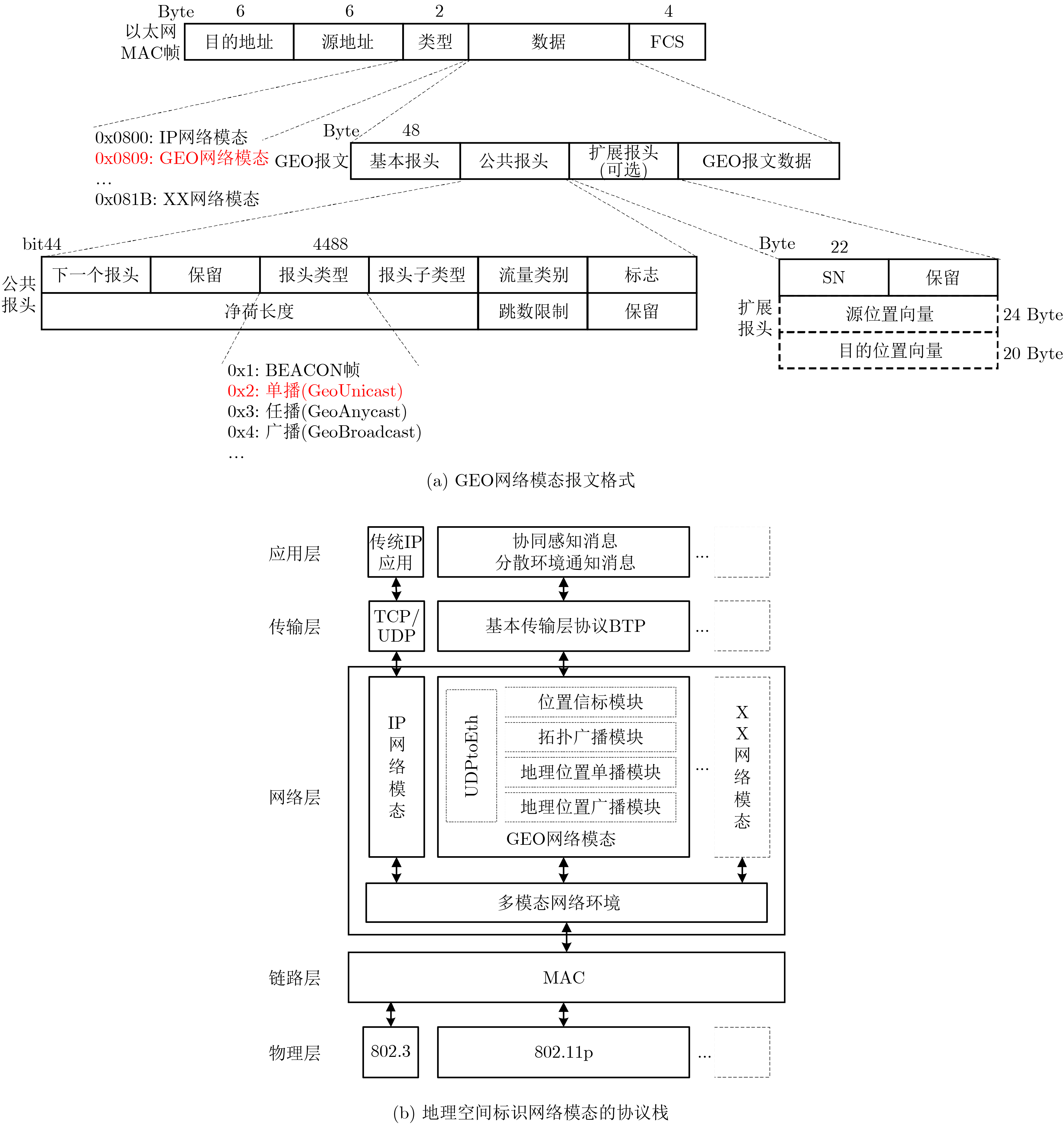
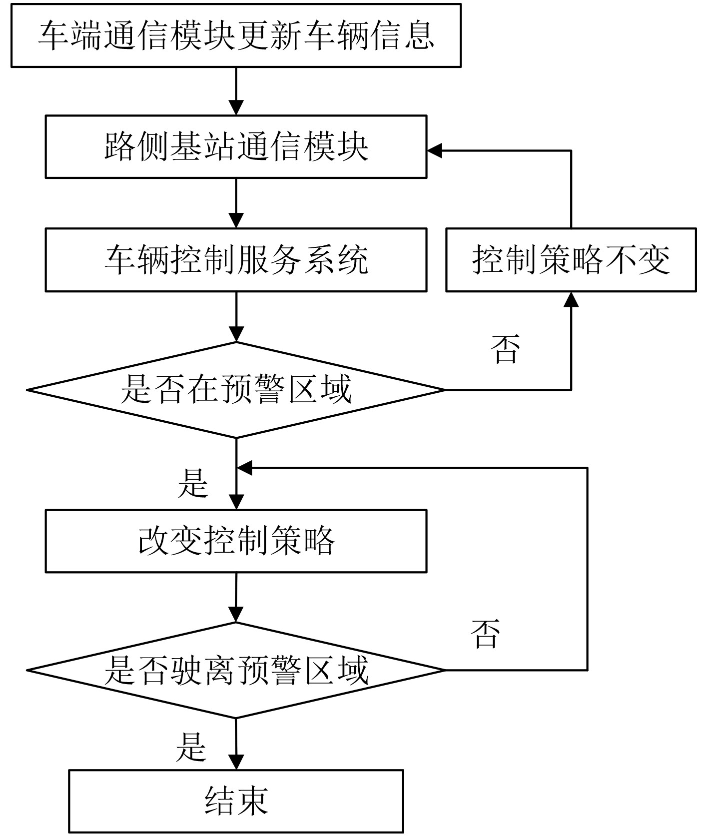
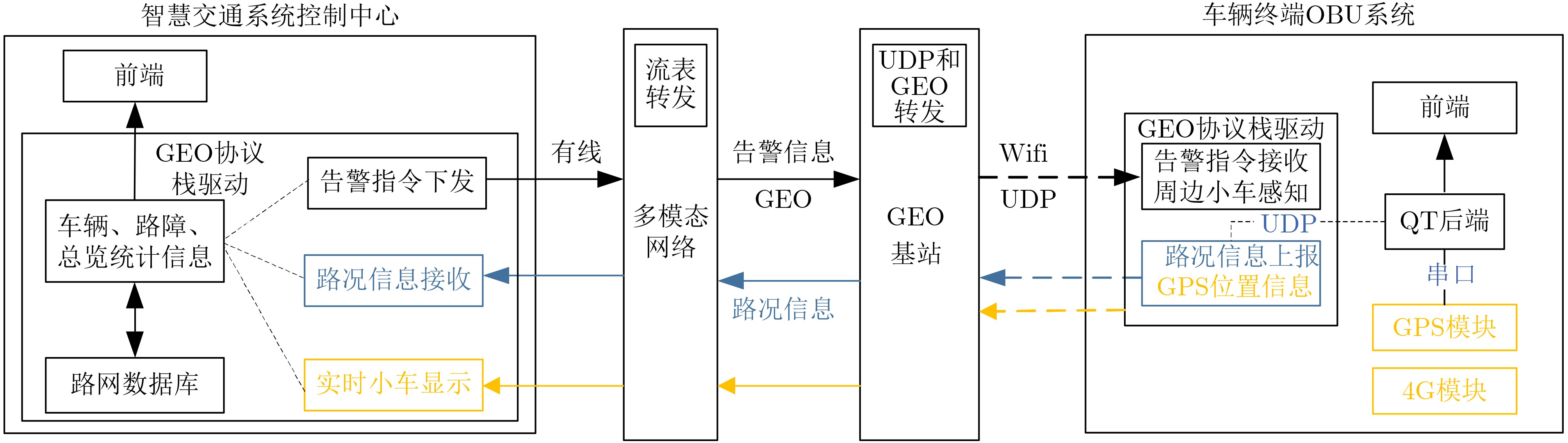
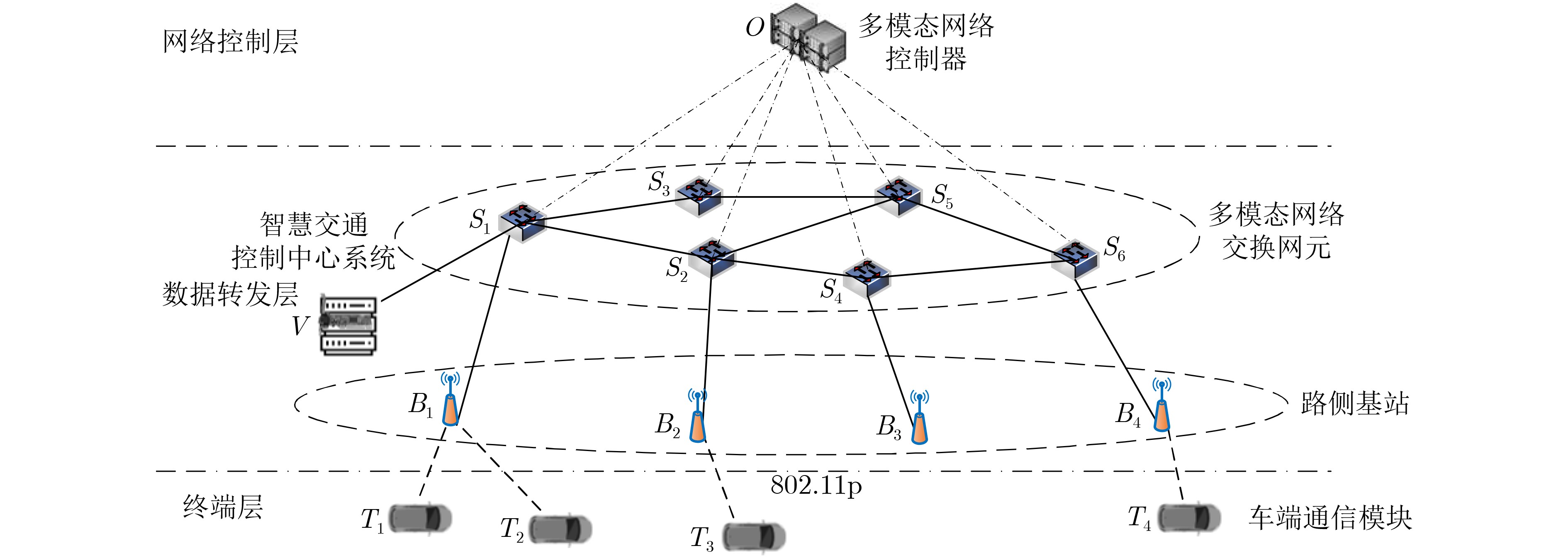
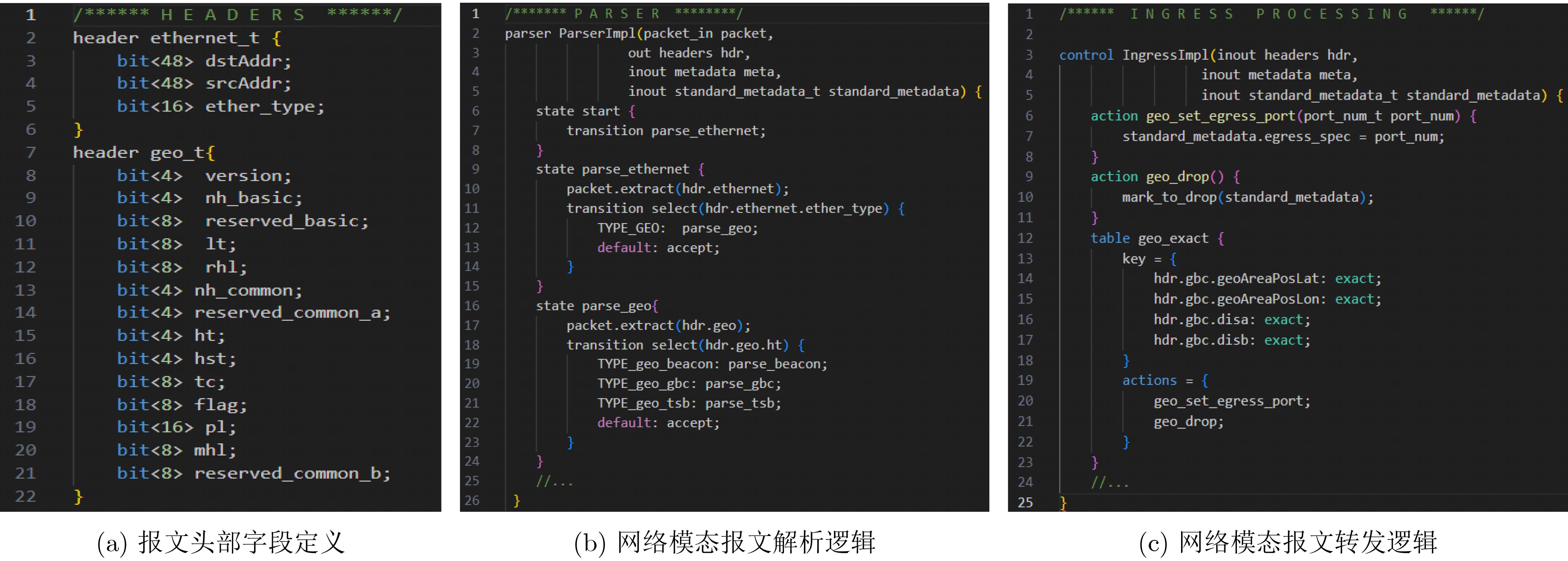
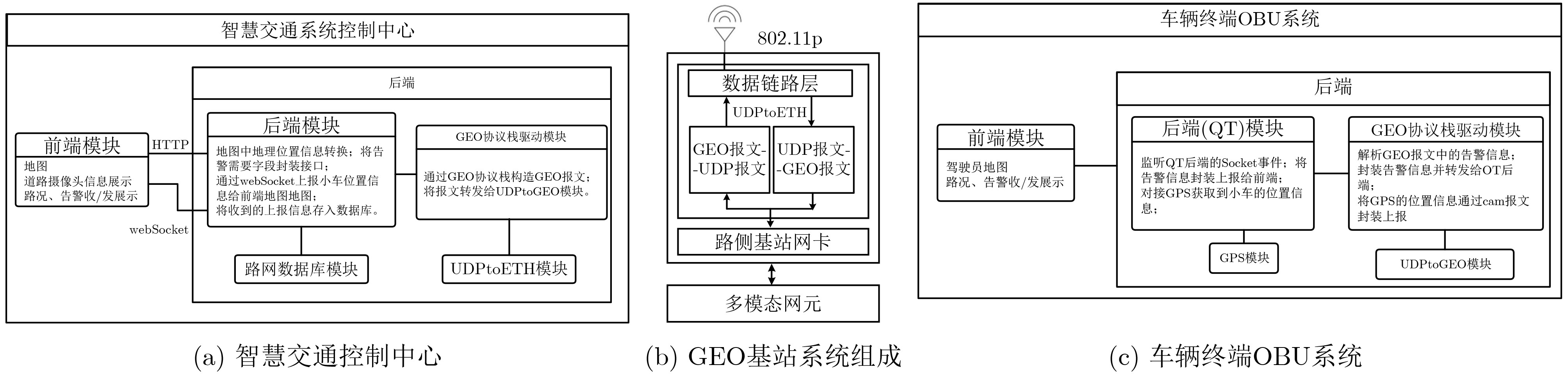
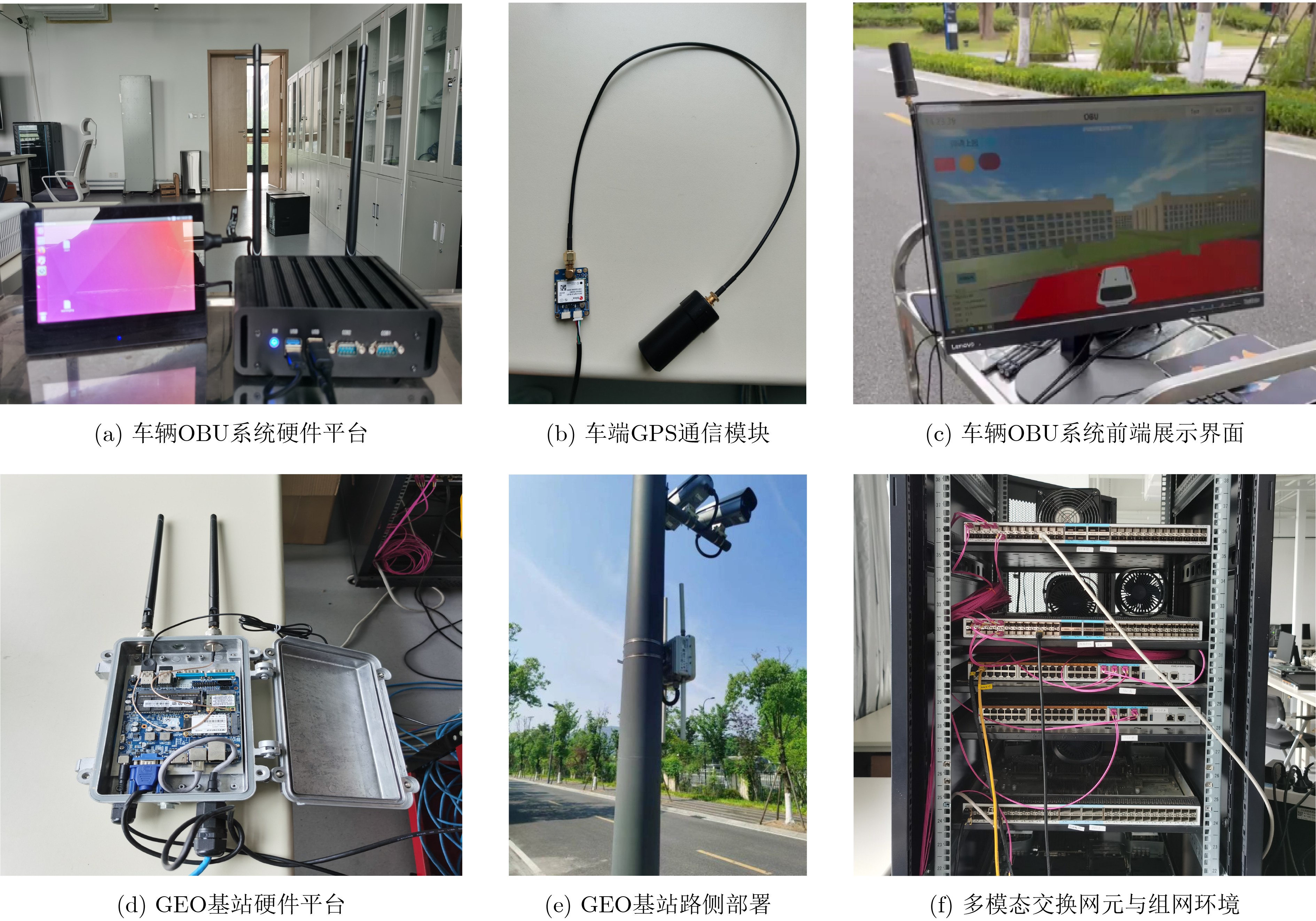
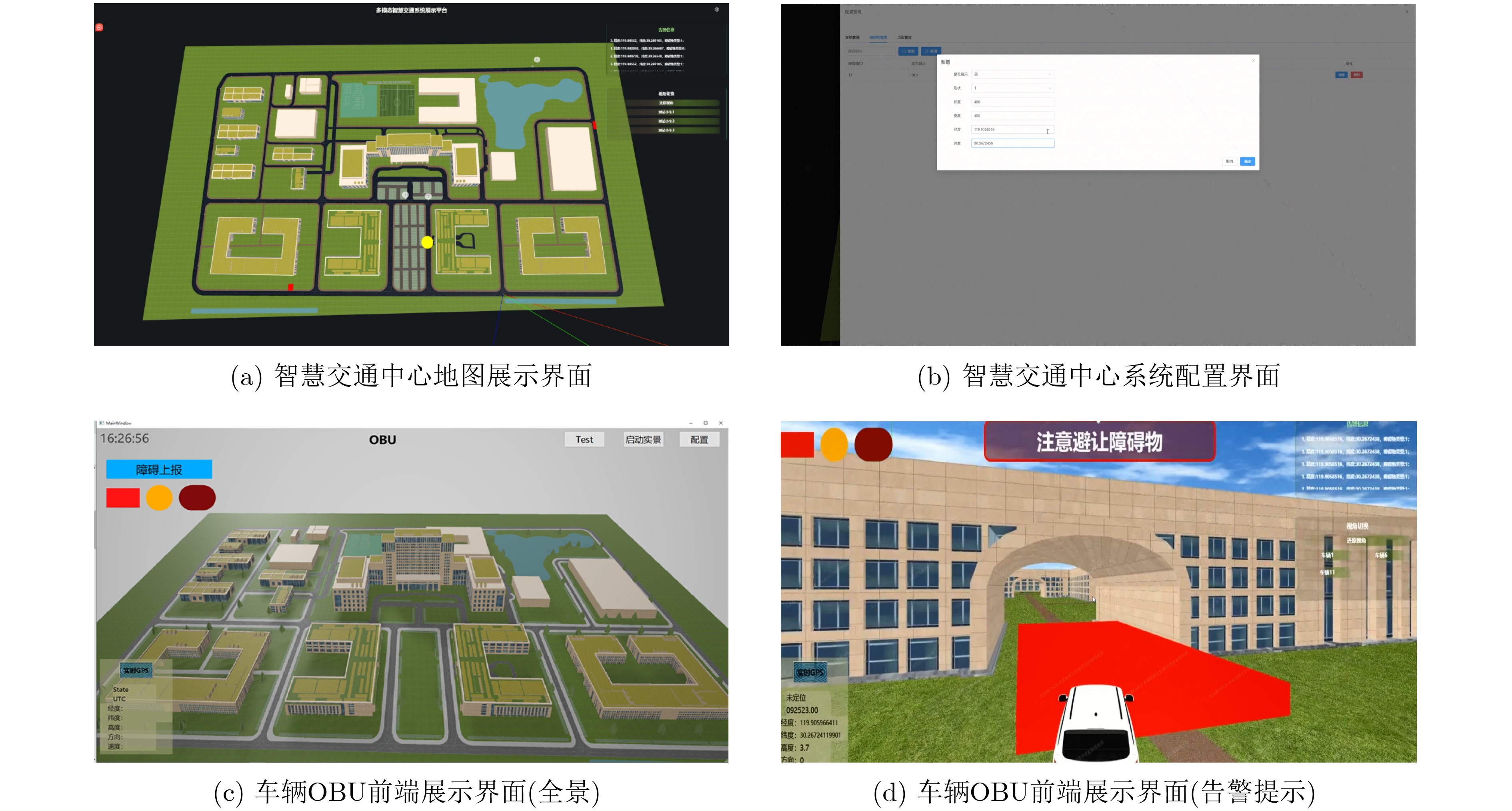
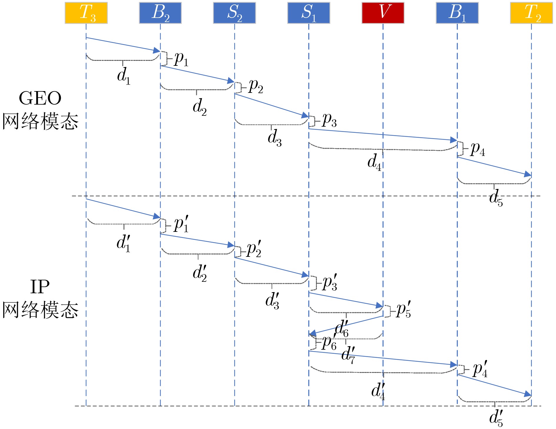
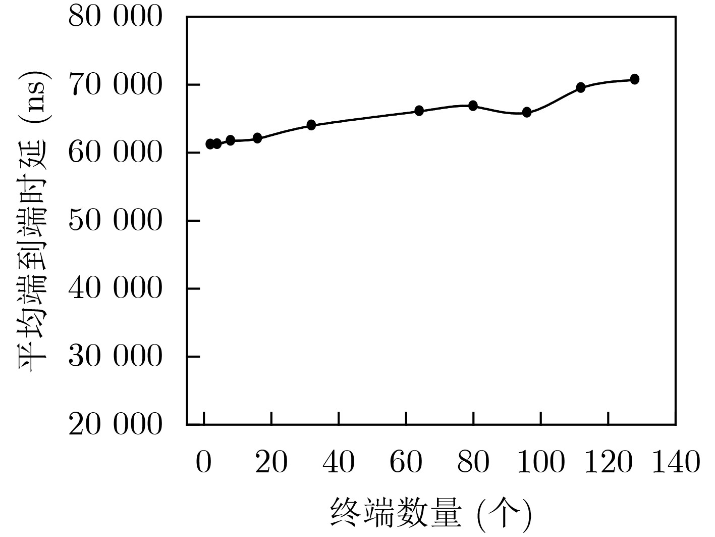
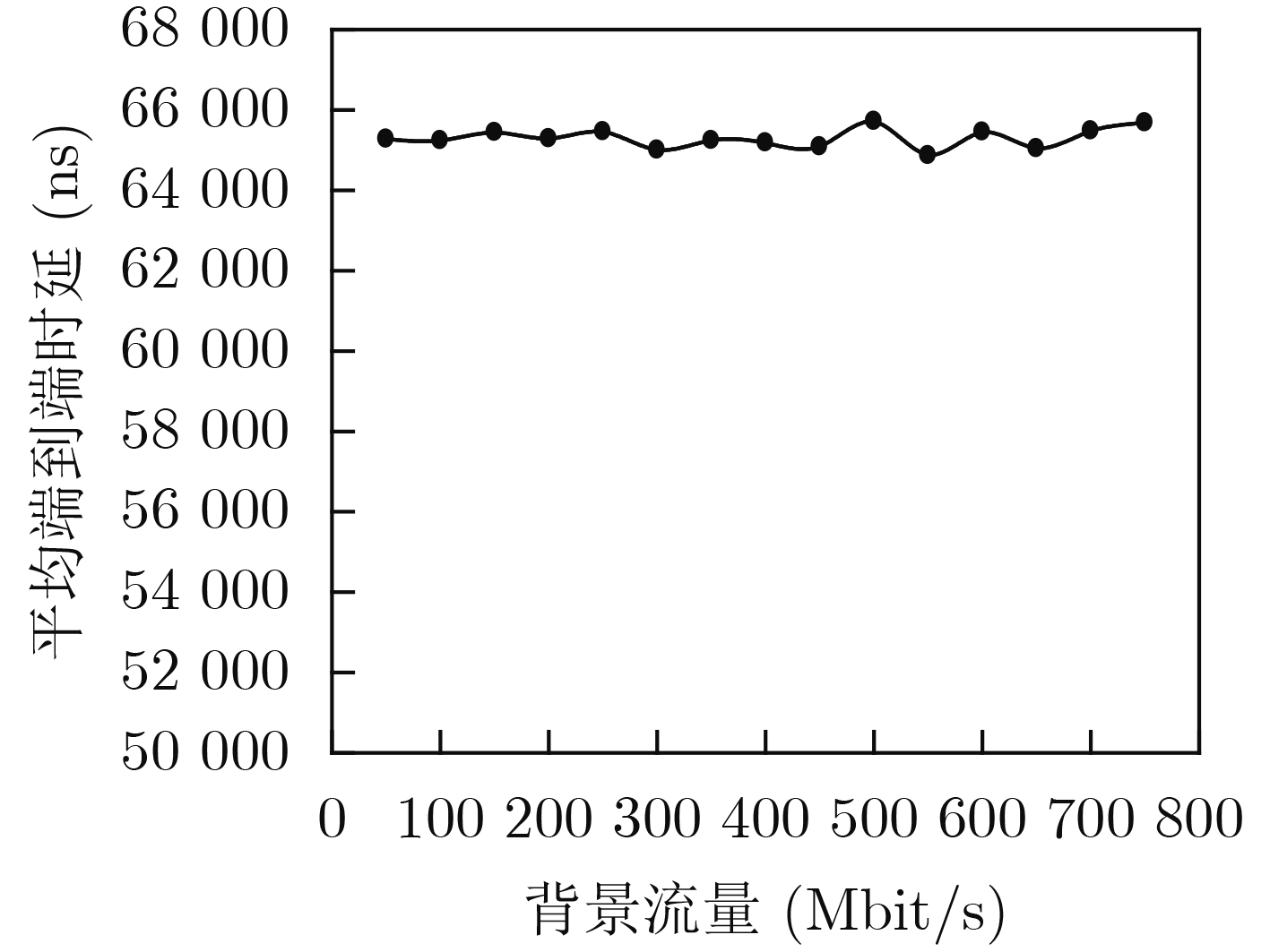
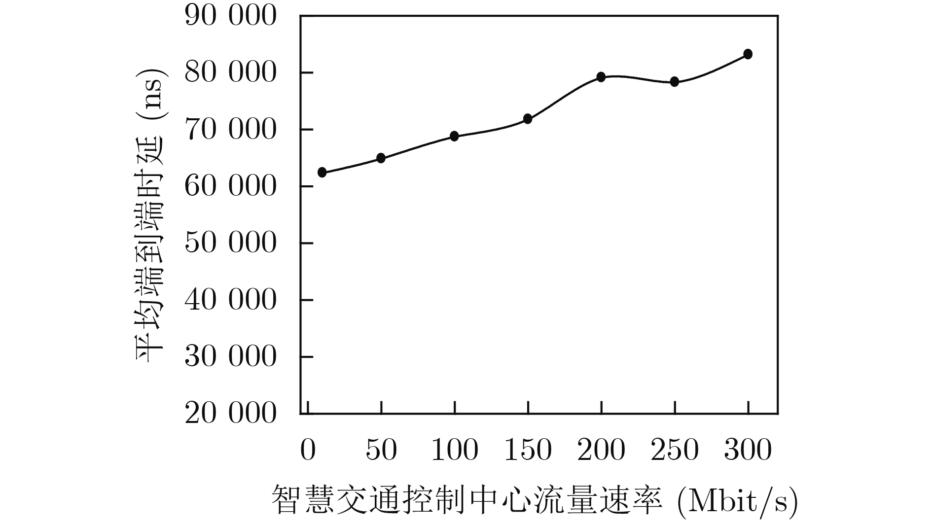
Abstract:Objective Vehicle-infrastructure cooperative Networks (V2X)are open and contain large numbers of nodes with high mobility, frequent topology changes, unstable wireless channels, and varied service requirements. These characteristics create challenges to efficient data transmission. A flexible network that supports rapid reconfiguration to meet different service requirements is considered essential in Intelligent Transportation Systems (ITS). With the development of programmable network technologies, programmable data-plane techniques are shifting the architecture from rigid designs to adaptive and flexible systems. In this work, a protocol standard based on geospatial information is proposed and combined with a polymorphic network architecture to design a geospatial identifier network modal. In this modal, the traditional three-layer protocol structure is replaced by packet forwarding based on geospatial identifiers. Packets carry geographic location information, and forwarding is executed directly according to this information. Addressing and routing based on geospatial information are more efficient and convenient than traditional IP-based approaches. A vehicle-infrastructure cooperative traffic system based on geospatial identifiers is further designed for intelligent transportation scenarios. This system supports direct geographic forwarding for road safety message dissemination and traffic information exchange. It enhances safety and improves route-planning efficiency within V2X. Methods The geospatial identifier network modal is built on a protocol standard that uses geographic location information and a flexible polymorphic network architecture. In this design, the traditional IP addressing mechanism in the three-layer network is replaced by a geospatial identifier protocol, and addressing and routing are executed on programmable polymorphic network elements. To support end-to-end transmission, a protocol stack for the geospatial identifier network modal is constructed, enabling unified transmission across different network modals. A dynamic geographic routing mechanism is further developed to meet the transmission requirements of the GEO modal. This mechanism functions in a multimodal network controller and uses the relatively stable coverage of roadside base stations to form a two-level mapping: “geographic region-base station/geographic coordinates-terminal.” This mapping supports precise path matching for GEO modal packets and enables flexible, centrally controlled geographic forwarding. To verify the feasibility of the geospatial identifier network modal, a vehicle-infrastructure cooperative intelligent transportation system supporting geospatial identifier addressing is developed. The system is designed to facilitate efficient dissemination of road safety and traffic information. The functional requirements of the system are analyzed, and the business processing flow and overall architecture are designed. Key hardware and software modules are also developed, including the geospatial representation data-plane code, traffic control center services, roadside base stations, and in-vehicle terminals, and their implementation logic is presented. Results and Discussions System evaluation is carried out from four aspects: evaluation environment, operational effectiveness, theoretical analysis, and performance testing. A prototype intelligent transportation system is deployed, as shown in Figure 7 and Figure 8. The prototype demonstrates correct message transmission based on the geospatial identifier modal. A typical vehicle-to-vehicle communication case is used to assess forwarding efficiency, where an onboard terminal (T3) sends a road-condition alert (M) to another terminal (T2). Sequence-based analysis is applied to compare forwarding performance between the GEO modal and a traditional IP protocol. Theoretical analysis indicates that the GEO modal provides higher forwarding efficiency, as shown in Fig. 9 . Additional performance tests are conducted by adjusting the number of terminals (Fig. 10 ), background traffic (Fig. 11 ), and the traffic of the control center (Fig. 12 ) to observe the transmission behavior of geospatial identifier packets. The results show that the intelligent transportation system maintains stable and efficient transmission performance under varying network conditions. System evaluation confirms its suitability for typical vehicle-infrastructure cooperative communication scenarios, supporting massive connectivity and elastic traffic loads.Conclusions By integrating a flexible polymorphic network architecture with a protocol standard based on geographic information, a geospatial identifier network modal is developed and implemented. The modal enables direct packet forwarding based on geospatial location. A prototype vehicle-infrastructure cooperative intelligent transportation system using geospatial identifier addressing is also designed for intelligent transportation scenarios. The system supports applications such as road-safety alerts and traffic information broadcasting, improves vehicle safety, and enhances route-planning efficiency. Experimental evaluation shows that the system maintains stable and efficient performance under typical traffic conditions, including massive connectivity, fluctuating background traffic, and elastic service loads. With the continued development of vehicular networking technologies, the proposed system is expected to support broader intelligent transportation applications and contribute to safer and more efficient mobility systems. -
1 路由表项计算过程的类Python伪代码表示
1 def compute_geo_routing_entry(self, src_switch,
dest_coords):2 # 步骤1:地理编码,将地理坐标转化为GeoHash编码 3 target_geohash = geohash_encode(dest_coords,
precision=6)4 # 步骤2:查找目标区域对应的边缘交换机(网络出口) 5 edge_switches = self.geo_area_to_switches.get(target_
geohash[:4]) # 使用较粗前缀匹配区域6 # 步骤3:计算最优路径(综合网络与地理因素) 7 初始化 best_path, min_metric 8 for edge_sw in edge_switches: 9 path = self.find_shortest_path(src_switch, edge_sw)
# 基于拓扑查找最短路径10 network_cost = self.calculate_path_cost(path) # 计算
网络代价11 geo_distance = haversine_distance(src_switch,
target_geohash) # 计算地理距离惩罚12 total_metric = network_cost + 0.1 * geo_distance #
计算综合度量13 if total_metric < min_metric: 14 min_metric = total_metric 15 best_path = path 16 # 步骤4:生成流表项 17 next_hop = best_path[1] # 第1跳的下一跳 18 out_port = self.topology.get_port(src_switch, next_hop)
# 转发端口19 flow_entry = { 'priority': 100, 'match': {'dest_prefix':
target_geo}, 'actions': [{'type': 'OUTPUT', 'port':
out_port}]} # 产生流表项20 return flow_entry  下载: 导出CSV
-
[1] 中共中央, 国务院. 交通强国建设纲要[R]. 北京: 中华人民共和国中央人民政府, 2019.State Council. Outline for building a powerful transportation country[R]. Beijing: The Central People’s Government of the People’s Republic of China, 2019. [2] 交通运输部, 国家铁路局, 中国民用航空局, 等. 加快建设交通强国五年行动计划(2023—2027年)[R]. 北京: 交通运输部办公厅, 2023.Ministry of Transport, National Railway Administration, Civil Aviation Administration of China, et al. Five-year action plan for accelerating the construction of a strong transportation country (2023–2027)[R]. Beijing: Office of the Ministry of Transport, 2023. [3] 齐晓鑫. 低轨卫星网络路由算法与拓扑控制策略研究[D]. [博士论文], 西安电子科技大学, 2022. doi: 10.27389/d.cnki.gxadu.2022.000103.QI Xiaoxin. Research on routing algorithm and topology control strategy of LEO satellite networks[D]. [Ph. D. dissertation], Xidian University, 2022. doi: 10.27389/d.cnki.gxadu.2022.000103. [4] AL-OMAISI H, SUNDARARAJAN E A, ALSAQOUR R, et al. GeoISA: A new road-topology-assisted geo-based content discovery scheme for vehicular named data networking[J]. Vehicular Communications, 2023, 40: 100573. doi: 10.1016/j.vehcom.2023.100573. [5] HAO Haiyan, WANG Yan, DU Lili, et al. Enabling smart curb management with spatiotemporal deep learning[J]. Computers, Environment and Urban Systems, 2023, 99: 101914. doi: 10.1016/j.compenvurbsys.2022.101914. [6] LI Dongshuang, YU Zhaoyuan, LUO Wen, et al. Optimal route searching with multiple dynamical constraints——a geometric algebra approach[J]. ISPRS International Journal of Geo-Information, 2018, 7(5): 172. doi: 10.3390/ijgi7050172. [7] LIU Baoju, LONG Jun, DENG Min, et al. An adaptive route planning method of connected vehicles for improving the transport efficiency[J]. ISPRS International Journal of Geo-Information, 2022, 11(1): 39. doi: 10.3390/ijgi11010039. [8] KARP B and KUNG H T. GPSR: Greedy perimeter stateless routing for wireless networks[C]. The 6th Annual International Conference on Mobile Computing and Networking, Boston, USA, 2000: 243–254. doi: 10.1145/345910.345953. [9] MAZOUZI M, MERSHAD K, CHEIKHROUHOU O, et al. Agent-based reactive geographic routing protocol for internet of vehicles[J]. IEEE Access, 2023, 11: 79954–79973. doi: 10.1109/ACCESS.2023.3299230. [10] ETEMAD M, SOARES JÚNIOR A, and MATWIN S. Predicting transportation modes of GPS trajectories using feature engineering and noise removal[C]. The 31st Canadian Conference on Artificial Intelligence, Toronto, Canada, 2018: 259–264. doi: 10.1007/978-3-319-89656-4_24. [11] NISHIYAMA H, TADA Y, KATO N, et al. Toward optimized traffic distribution for efficient network capacity utilization in two-layered satellite networks[J]. IEEE Transactions on Vehicular Technology, 2013, 62(3): 1303–1313. doi: 10.1109/TVT.2012.2227861. [12] ZHENG Yu, XIE Xing, and MA Weiying. GeoLife: A collaborative social networking service among user, location and trajectory[J]. IEEE Data Engineering Bulletin, 2010, 33(1): 32–39. [13] HU Yuxiang, LI Dan, SUN Penghao, et al. Polymorphic smart network: An open, flexible and universal architecture for future heterogeneous networks[J]. IEEE Transactions on Network Science and Engineering, 2020, 7(4): 2515–2525. doi: 10.1109/TNSE.2020.3006249. [14] 胡宇翔, 伊鹏, 孙鹏浩, 等. 全维可定义的多模态智慧网络体系研究[J]. 通信学报, 2019, 40(8): 1–12. doi: 10.11959/j.issn.1000-436x.2019192.HU Yuxiang, YI Peng, SUN Penghao, et al. Research on the full-dimensional defined polymorphic smart network[J]. Journal on Communications, 2019, 40(8): 1–12. doi: 10.11959/j.issn.1000-436x.2019192. [15] DUAN Xiaoyu, LIU Yanan, and WANG Xianbin. SDN enabled 5G-VANET: Adaptive vehicle clustering and beamformed transmission for aggregated traffic[J]. IEEE Communications Magazine, 2017, 55(7): 120–127. doi: 10.1109/MCOM.2017.1601160. [16] CAMPOLO C, MOLINARO A, and SCOPIGNO R. Vehicular Ad Hoc Networks: Standards, Solutions, and Research[M]. Cham: Springer, 2015: 221–247. doi: 10.1007/978-3-319-15497-8. [17] VUKOVIC T. Hilbert-geohash-hashing geographical point data using the Hilbert space-filling curve[D]. [Master dissertation], NTNU, 2016. -


图(12) / 表(1)
计量
- 文章访问数: 450
- HTML全文浏览量: 290
- PDF下载量: 82
- 被引次数: 0
 下载:
下载:
