Advanced Search
Volume 47 Issue 5
May  2025
Turn off MathJax
Article Contents
ZHANG Xu, YANG Jie. Global Navigation Satellite System Partial Ambiguity Resolution Method Integrating Ionospheric Delay Correction and Multi-frequency Signal Optimization[J]. Journal of Electronics & Information Technology, 2025, 47(5): 1543-1553. doi: 10.11999/JEIT240682
Citation: ZHANG Xu, YANG Jie. Global Navigation Satellite System Partial Ambiguity Resolution Method Integrating Ionospheric Delay Correction and Multi-frequency Signal Optimization[J]. Journal of Electronics & Information Technology, 2025, 47(5): 1543-1553. doi: 10.11999/JEIT240682

Global Navigation Satellite System Partial Ambiguity Resolution Method Integrating Ionospheric Delay Correction and Multi-frequency Signal Optimization

doi: 10.11999/JEIT240682 cstr: 32379.14.JEIT240682
Funds:  The Scientific Research Foundation for High-level Talents of Anhui University of Science and Technology (2024yjrc177), The National Key Research and Development Program of China (2020YFB1710800), The National Natural Science Foundation of China (51879211)
  • Received Date: 2024-07-31
  • Rev Recd Date: 2025-04-08
  • Available Online: 2025-04-29
  • Publish Date: 2025-05-01
  •   Objective  Global Navigation Satellite System (GNSS) high-precision positioning is widely applied due to its accuracy. However, the integrity of the Ambiguity Resolution (AR) process remains limited, particularly in occluded environments and over long baselines. Traditional AR methods are often affected by ionospheric delay errors, which become substantial when the ionospheric conditions differ between reference and rover stations. This paper proposes a Modified Partial Ambiguity Resolution (MPAR) method that integrates ionospheric delay correction models with multi-frequency signal optimization. The combined approach improves GNSS positioning accuracy and reliability under varied environmental and baseline conditions.  Methods  To reduce the effect of ionospheric delay on AR, this study incorporates an Ionospheric delay correction model into the geometry-free Cascade Integer Resolution (ICIR) method. ICIR resolves the integer ambiguities of Extra-Wide Lane (EWL), Wide Lane (WL), and Narrow Lane (NL) combinations using carrier phase measurements with different wavelengths. The ionospheric delay correction model enables compensation for differential delays between stations, improving AR accuracy, particularly over long baselines. To further enhance data usage—especially in cases of low-quality observations—a two-stage partial AR strategy is employed. In the first stage, the ICIR method is applied to an optimal subset of satellites selected based on tri-frequency availability and high elevation angles. For the non-optimal subset, which may include satellites with limited frequencies or weaker signal quality, the Least-Squares AMBiguity Decorrelation Adjustment (LAMBDA) method is used in geometric mode, with assistance from the ambiguity-fixed results of the optimal subset. This integrated approach reduces computational complexity and improves the AR success rate and reliability. The MPAR method proceeds as follows: (1) select the optimal satellite subset based on frequency availability and elevation angle; (2) apply the ICIR method to resolve ambiguities in this subset; (3) use the fixed ambiguities from the optimal subset to assist in resolving ambiguities for the non-optimal subset via the LAMBDA method; (4) obtain the final integer ambiguity solution for the full epoch.  Results and Discussions  The proposed MPAR method is validated using two datasets collected under different environments: one from Tokyo, characterized by complex urban occlusion and long baselines (approximately 1 700 meters), and another from Wuhan, featuring an open campus environment and short baselines (approximately 600 meters). The results show that the MPAR method outperforms traditional PAR methods in positioning accuracy, AR success rate, and computational efficiency. As shown in (Fig. 3) and (Fig. 5), satellite visibility in the Tokyo dataset is significantly affected by occlusion, leading to fewer available satellites compared to the Wuhan dataset. Despite these challenges, the MPAR method achieves the highest success rate and the lowest Average Standard Deviation (ASD) in all tested scenarios, including GPS, BDS, and dual-system modes (Table 2 and Table 4). In the Tokyo dataset, the MPAR method reduces the ASD by up to 40% compared to traditional methods, reflecting its robustness in complex environments. The AR success rate also significantly improves with the MPAR method. As presented in (Table 3) and (Table 5), the MPAR method achieves AR success rates exceeding 86% in all tested scenarios, with a peak rate of 99.4% in the GPS/BDS dual-system mode of the Wuhan dataset. These results demonstrate the effectiveness of the proposed method in enhancing AR reliability under challenging conditions. In terms of computational efficiency, the MPAR method exhibits balanced performance. Although the use of the ionospheric delay correction model slightly increases computational complexity, the overall efficiency remains competitive, with an average solution time of approximately 0.13 seconds per epoch (Table 3 and Table 5). This performance supports the suitability of the MPAR method for real-time applications. Furthermore, Table 3 (Tokyo dataset) and Table 5 (Wuhan dataset) summarize the performance metrics of the five AR methods evaluated. The MPARICIR method achieves the highest AR success rates across all systems and environments, reaching 93.1% and 99.4% for the Tokyo and Wuhan datasets, respectively. Notably, the MPARICIR method maintains a high success rate while reducing computation time compared to other methods, indicating its efficiency. These results support the effectiveness and robustness of the proposed MPARICIR method in improving GNSS positioning performance.  Conclusions  This study proposes an MPAR method for high-precision GNSS positioning. By integrating ionospheric delay correction models with multi-frequency signal optimization, MPAR combines the strengths of geometry-free and geometry-based AR strategies. The method effectively reduces the effect of ionospheric delay, particularly over long baselines and in occluded environments. Experimental results confirm that MPAR improves positioning accuracy, AR success rate, and computational efficiency relative to conventional methods. Its consistent performance across varied environments and baseline lengths highlights its suitability for broad application in high-precision GNSS positioning.
  • loading
  • [1]
    CHEN Jiajia, WANG Jun, YUAN Hong, et al. Performance analysis of a GNSS multipath detection and mitigation method with two low-cost antennas in RTK positioning[J]. IEEE Sensors Journal, 2022, 22(6): 4827–4835. doi: 10.1109/JSEN.2021.3068767.
    [2]
    KHODABANDEH A, ZAMINPARDAZ S, and NADARAJAH N. A study on multi-GNSS phase-only positioning[J]. Measurement Science and Technology, 2021, 32(9): 095005. doi: 10.1088/1361-6501/abeced.
    [3]
    CAI Jianqing, GRAFAREND E W, and HU Congwei. The total optimal search criterion in solving the mixed integer linear model with GNSS carrier phase observations[J]. GPS Solutions, 2009, 13(3): 221–230. doi: 10.1007/s10291-008-0115-y.
    [4]
    ZHANG Zhetao, LI Bofeng, HE Xiufeng, et al. Models, methods and assessment of four-frequency carrier ambiguity resolution for BeiDou-3 observations[J]. GPS Solutions, 2020, 24(4): 96. doi: 10.1007/s10291-020-01011-z.
    [5]
    TEUNISSEN P J G. The least-squares ambiguity decorrelation adjustment: A method for fast GPS integer ambiguity estimation[J]. Journal of Geodesy, 1995, 70(1/2): 65–82. doi: 10.1007/BF00863419.
    [6]
    周非, 杨铁军, 黄顺吉. 基线约束辅助整周模糊度求解研究[J]. 电子学报, 2004, 32(9): 1549–1552. doi: 10.3321/j.issn:0372-2112.2004.09.037.

    ZHOU Fei, YANG Tiejun, and HUANG Shunji. Research of ambiguity resolution with baseline constraint[J]. Acta Electronica Sinica, 2004, 32(9): 1549–1552. doi: 10.3321/j.issn:0372-2112.2004.09.037.
    [7]
    GUO Jiang, GENG Jianghui, ZENG Jing, et al. GPS/Galileo/BDS phase bias stream from Wuhan IGS analysis center for real-time PPP ambiguity resolution[J]. GPS Solutions, 2024, 28(2): 67. doi: 10.1007/s10291-023-01610-6.
    [8]
    ZHANG Zhiteng, LI Bofeng, GAO Yang, et al. Asynchronous and time-differenced RTK for ocean applications using the BeiDou short message service[J]. Journal of Geodesy, 2023, 97(1): 7. doi: 10.1007/s00190-023-01699-0.
    [9]
    刘增军, 彭竞, 吕志成, 等. 一种适用于长基线的改进CIR算法[J]. 国防科技大学学报, 2013, 35(2): 93–98. doi: 10.3969/j.issn.1001-2486.2013.02.017.

    LIU Zengjun, PENG Jing, LV Zhicheng, et al. An improved CIR for long baseline[J]. Journal of National University of Defense Technology, 2013, 35(2): 93–98. doi: 10.3969/j.issn.1001-2486.2013.02.017.
    [10]
    TANG Weiming, DENG Chenlong, SHI Chuang, et al. Triple-frequency carrier ambiguity resolution for Beidou navigation satellite system[J]. GPS Solutions, 2014, 18(3): 335–344. doi: 10.1007/s10291-013-0333-9.
    [11]
    NING Yafei and YUAN Yunbin. A modified geometry- and ionospheric-free combination for static three-carrier ambiguity resolution[J]. GPS Solutions, 2017, 21(4): 1633–1645. doi: 10.1007/s10291-017-0642-5.
    [12]
    TANG Weiming, SHEN Mingxing, DENG Chenlong, et al. Network-based triple-frequency carrier phase ambiguity resolution between reference stations using BDS data for long baselines[J]. GPS Solutions, 2018, 22(3): 73. doi: 10.1007/s10291-018-0737-7.
    [13]
    PU Yakun, SONG Min, YUAN Yunbin, et al. Triple-frequency ambiguity resolution for GPS/Galileo/BDS between long-baseline network reference stations in different ionospheric regions[J]. GPS Solutions, 2022, 26(4): 146. doi: 10.1007/s10291-022-01336-x.
    [14]
    JI Shengyue, CHEN Wu, ZHAO Chunmei, et al. Single epoch ambiguity resolution for Galileo with the CAR and LAMBDA methods[J]. GPS Solutions, 2007, 11(4): 259–268. doi: 10.1007/s10291-007-0057-9.
    [15]
    HAN Houzeng, WANG Jian, WANG Jinling, et al. Reliable partial ambiguity resolution for single-frequency GPS/BDS and INS integration[J]. GPS Solutions, 2017, 21(1): 251–264. doi: 10.1007/s10291-016-0519-z.
    [16]
    YAN Zhongbao and ZHANG Xiaohong. The performance of three-frequency GPS PPP-RTK with partial ambiguity resolution[J]. Atmosphere, 2022, 13(7): 1014. doi: 10.3390/atmos13071014.
    [17]
    LI Xin, LI Xingxing, JIANG Zihao, et al. A unified model of GNSS phase/code bias calibration for PPP ambiguity resolution with GPS, BDS, Galileo and GLONASS multi-frequency observations[J]. GPS Solutions, 2022, 26(3): 84. doi: 10.1007/s10291-022-01269-5.
    [18]
    ZHANG Xu and YANG Jie. MPARELAM: A robust approach for ambiguity resolution in complex RTK positioning scenarios[J]. IEEE Sensors Journal, 2023, 23(17): 19582–19589. doi: 10.1109/JSEN.2023.3293461.
    [19]
    CHEN Guang’e, LI Bofeng, ZHANG Zhiteng, et al. Integer ambiguity resolution and precise positioning for tight integration of BDS-3, GPS, GALILEO, and QZSS overlapping frequencies signals[J]. GPS Solutions, 2022, 26(1): 26. doi: 10.1007/s10291-021-01203-1.
    [20]
    FENG Shaojun and JOKINEN A. Integer ambiguity validation in high accuracy GNSS positioning[J]. GPS Solutions, 2017, 21(1): 79–87. doi: 10.1007/s10291-015-0506-9.
  • 加载中

Catalog

    通讯作者: 陈斌, bchen63@163.com
    • 1. 

      沈阳化工大学材料科学与工程学院 沈阳 110142

    1. 本站搜索
    2. 百度学术搜索
    3. 万方数据库搜索
    4. CNKI搜索

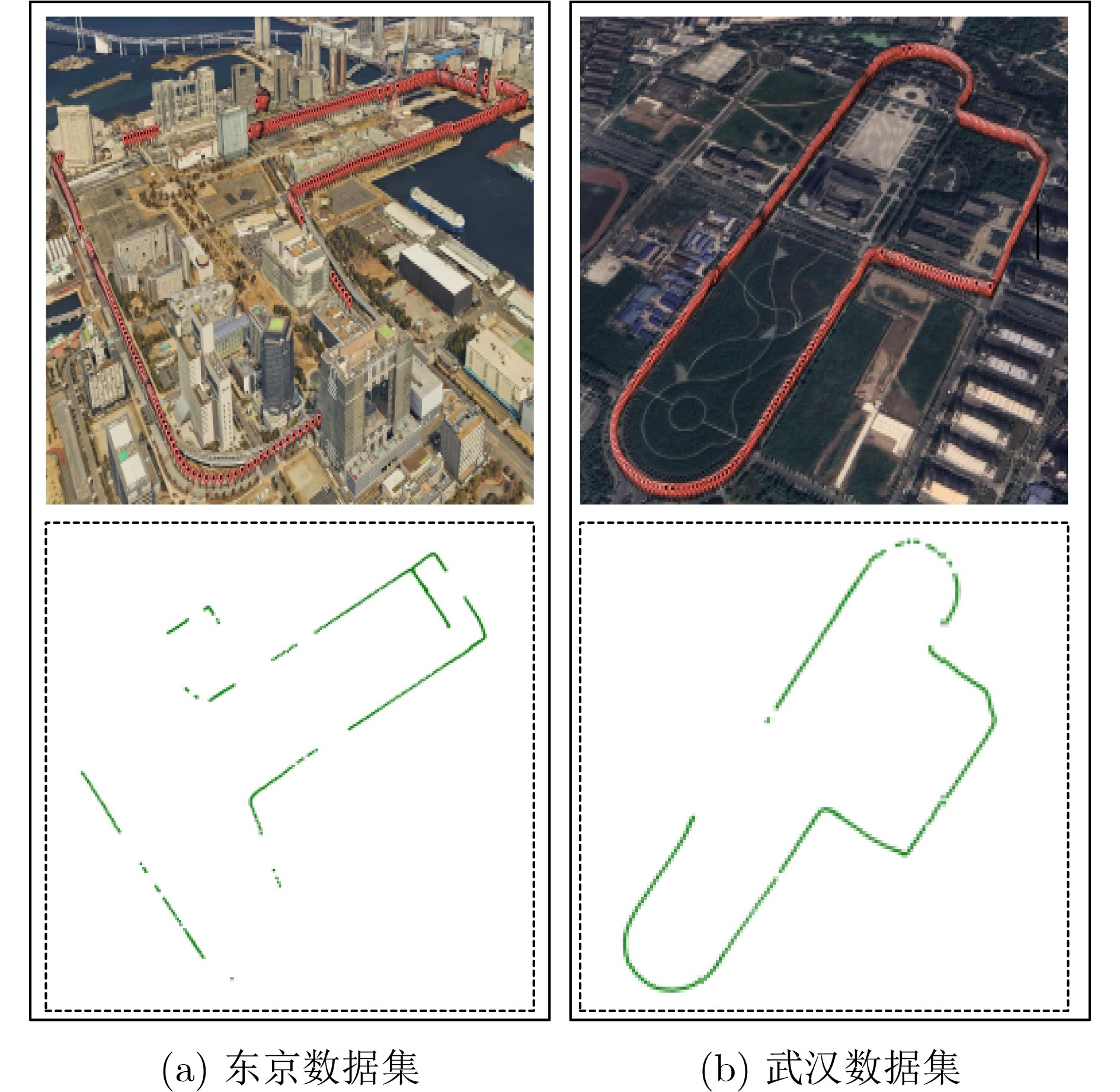
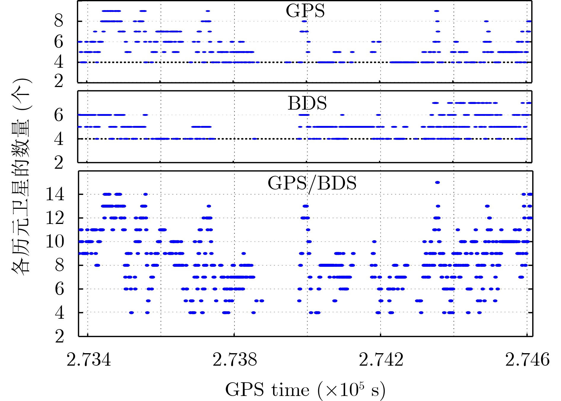
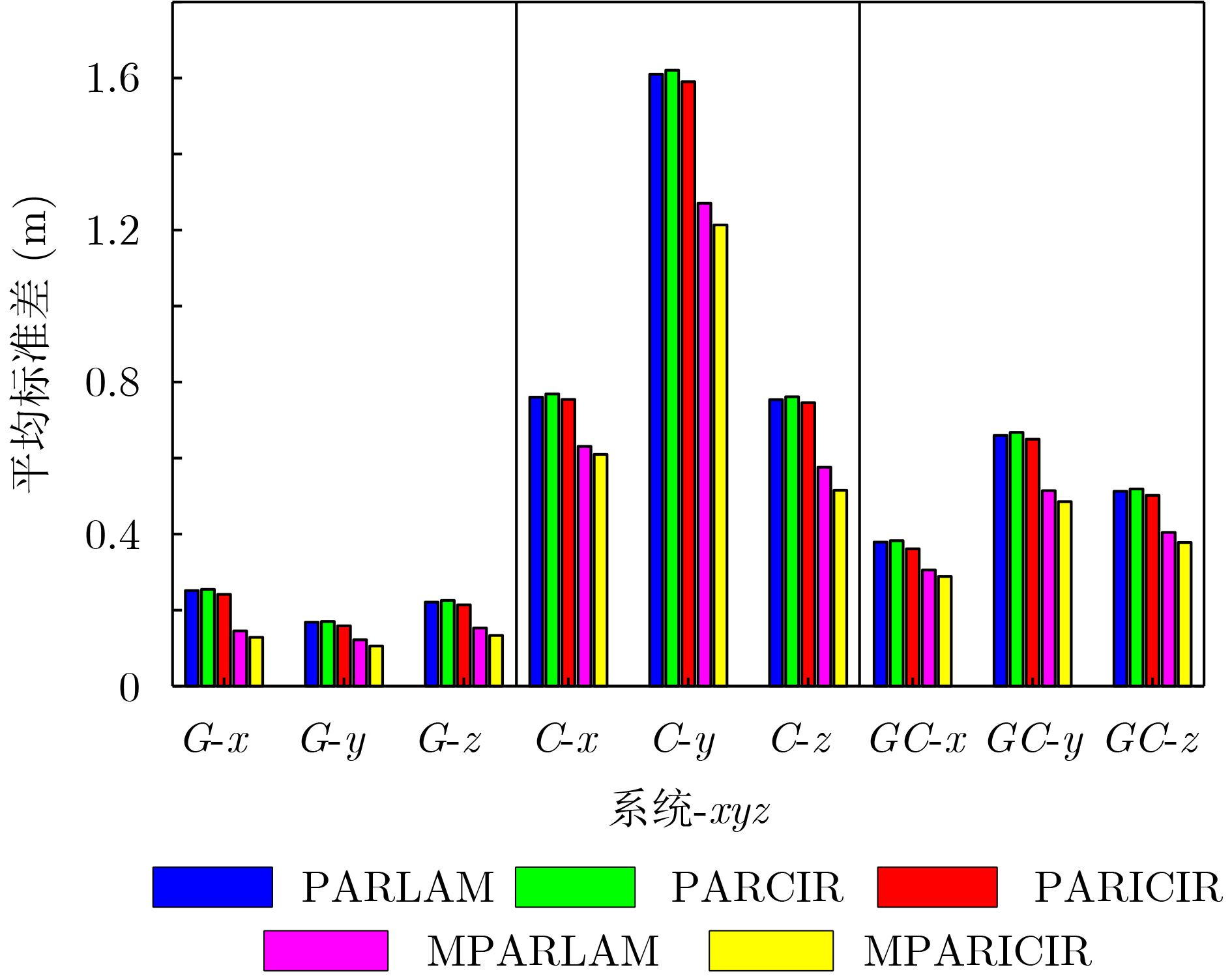
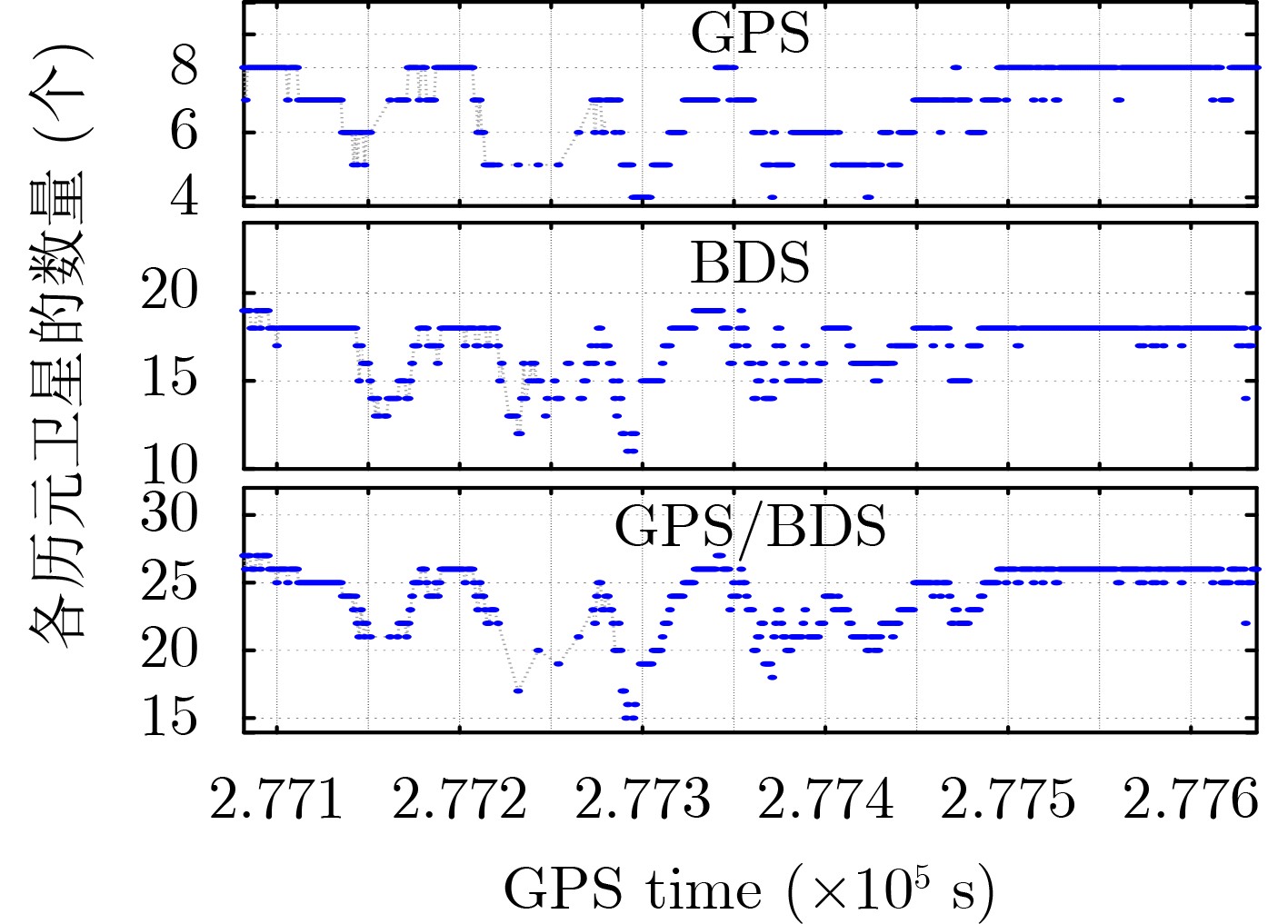
    Figures(6)  / Tables(5)

    Article Metrics

    Article views (234) PDF downloads(32) Cited by()
    Proportional views
    Related

    /

    DownLoad:  Full-Size Img  PowerPoint
    Return
    Return