Advanced Search
Turn off MathJax
Article Contents
MA Lixiang, MA Yuechen, YIN Ke, HAN Xiaolei, CHEN Longyong, ZHANG Bingchen. A Distributed Satellite Formation Method for SAR Three-Dimensional Tomography Applications[J]. Journal of Electronics & Information Technology. doi: 10.11999/JEIT260709
Citation: MA Lixiang, MA Yuechen, YIN Ke, HAN Xiaolei, CHEN Longyong, ZHANG Bingchen. A Distributed Satellite Formation Method for SAR Three-Dimensional Tomography Applications[J]. Journal of Electronics & Information Technology. doi: 10.11999/JEIT260709

A Distributed Satellite Formation Method for SAR Three-Dimensional Tomography Applications

doi: 10.11999/JEIT260709 cstr: 32379.14.JEIT260709
Funds:  The National Key Research and Development Program of China (2022YFB3901602)
  • Received Date: 2026-06-01
  • Accepted Date: 2026-10-16
  • Rev Recd Date: 2026-10-13
  • Available Online: 2026-10-25
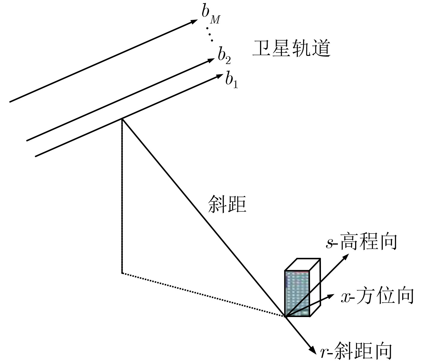
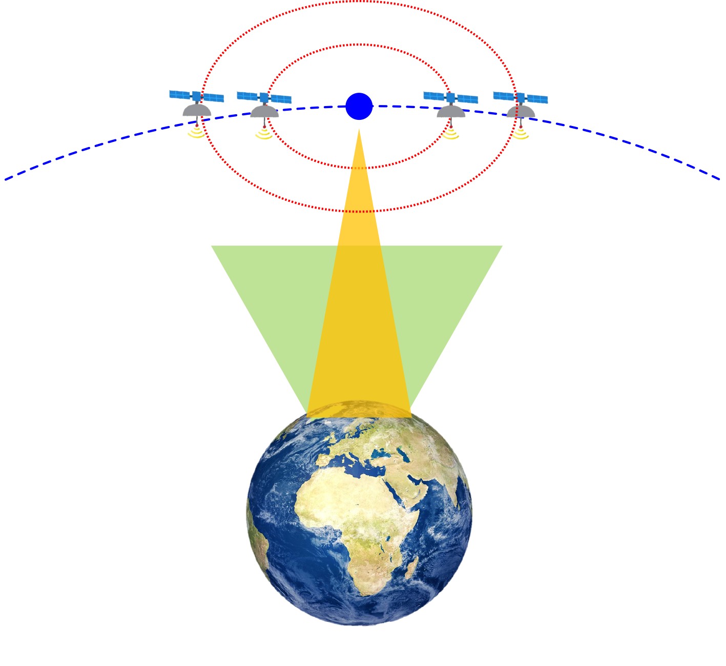
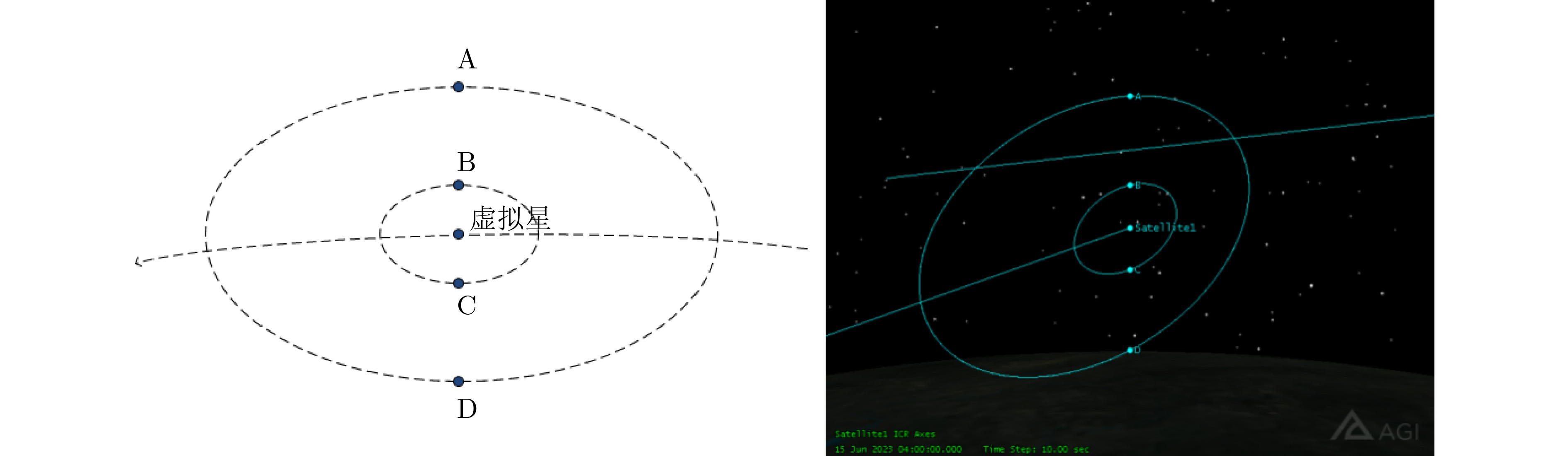
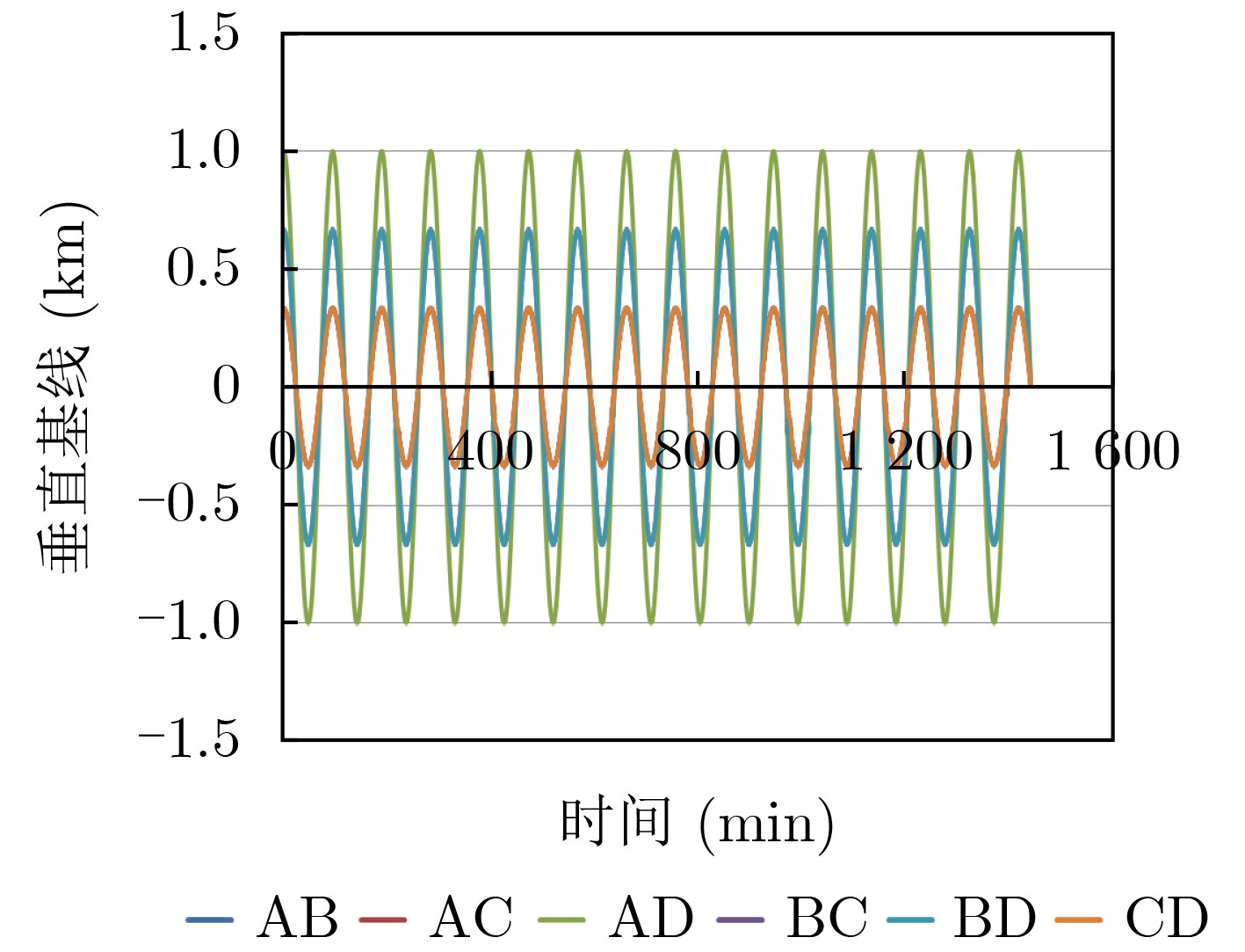
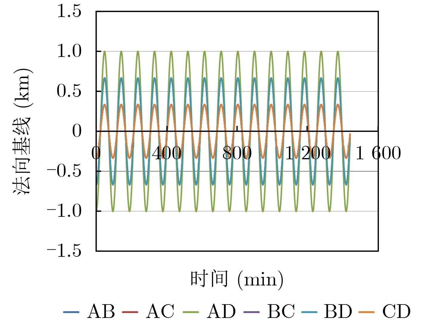
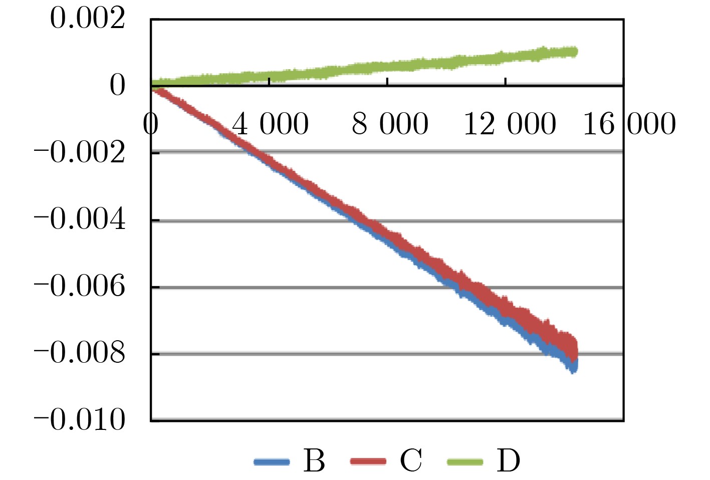
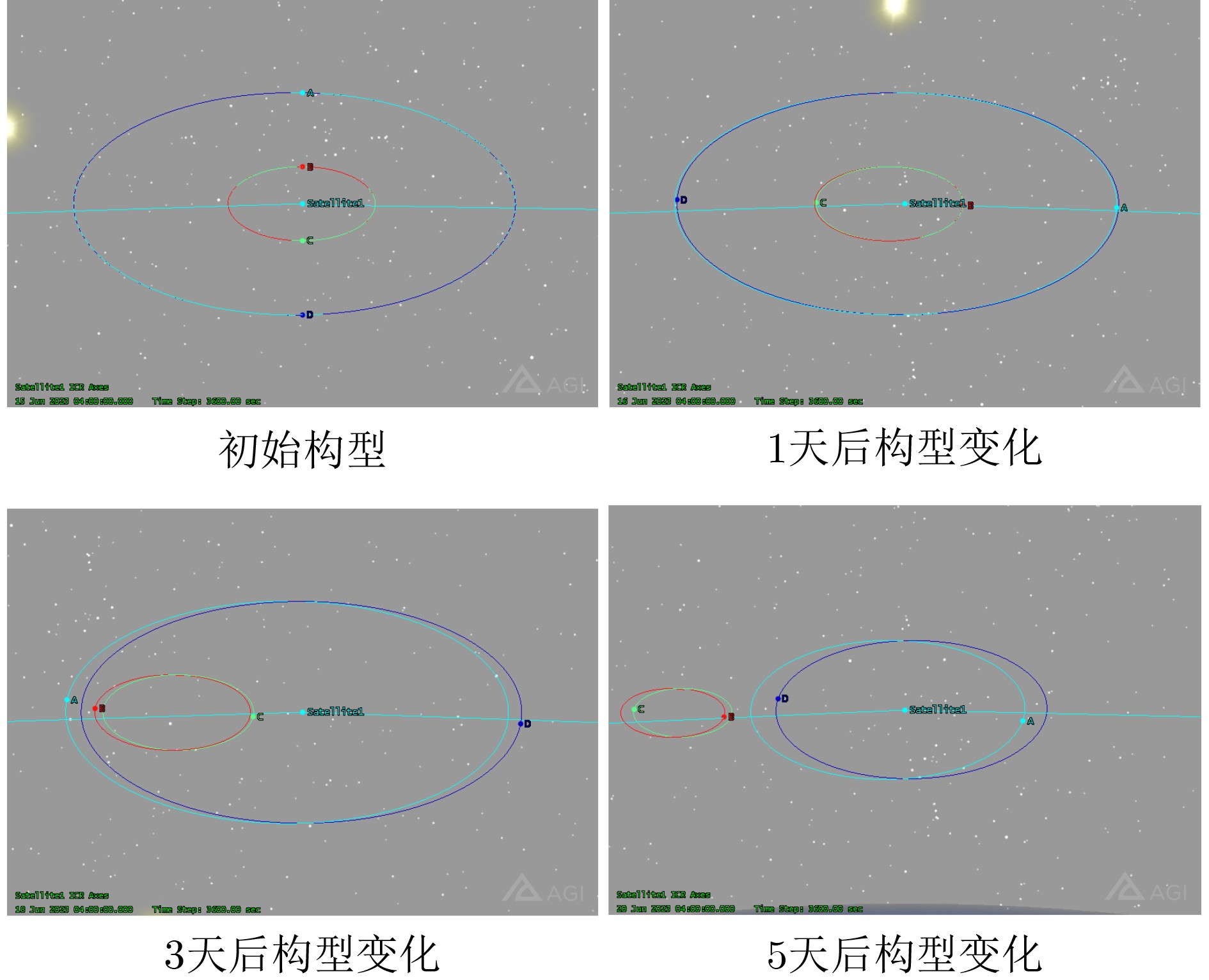
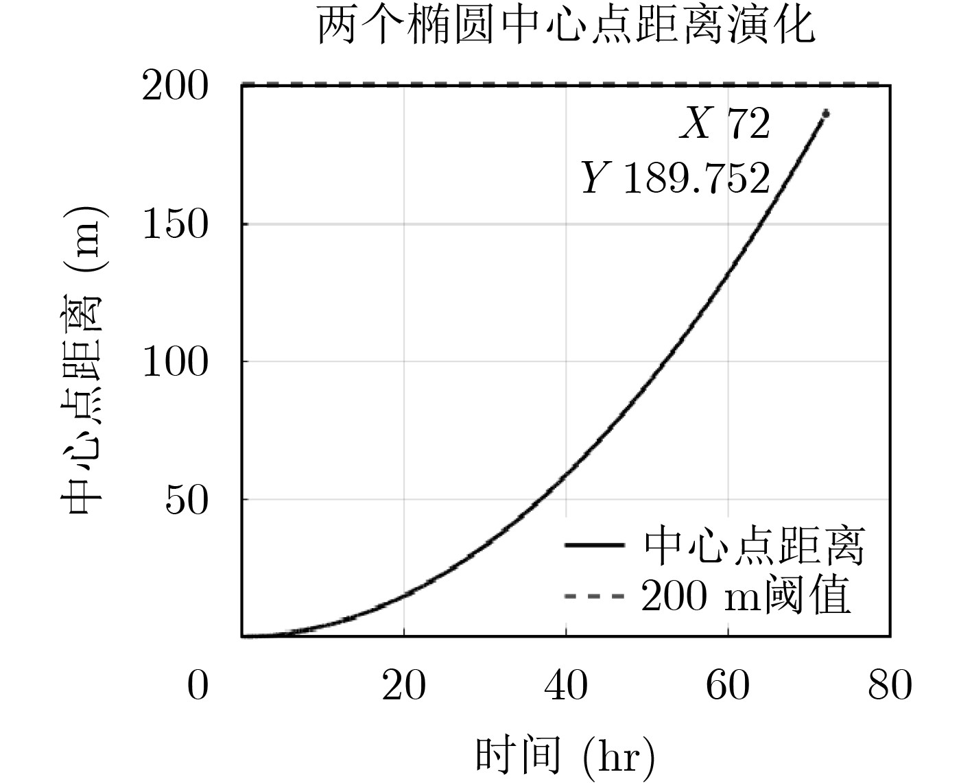
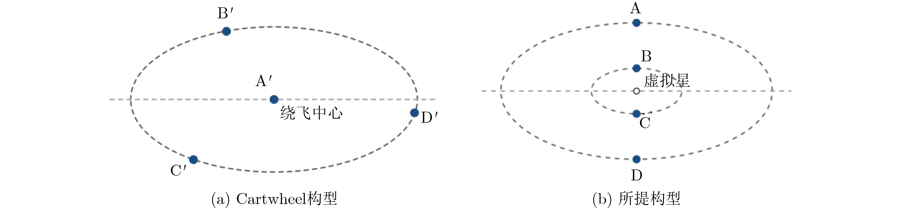
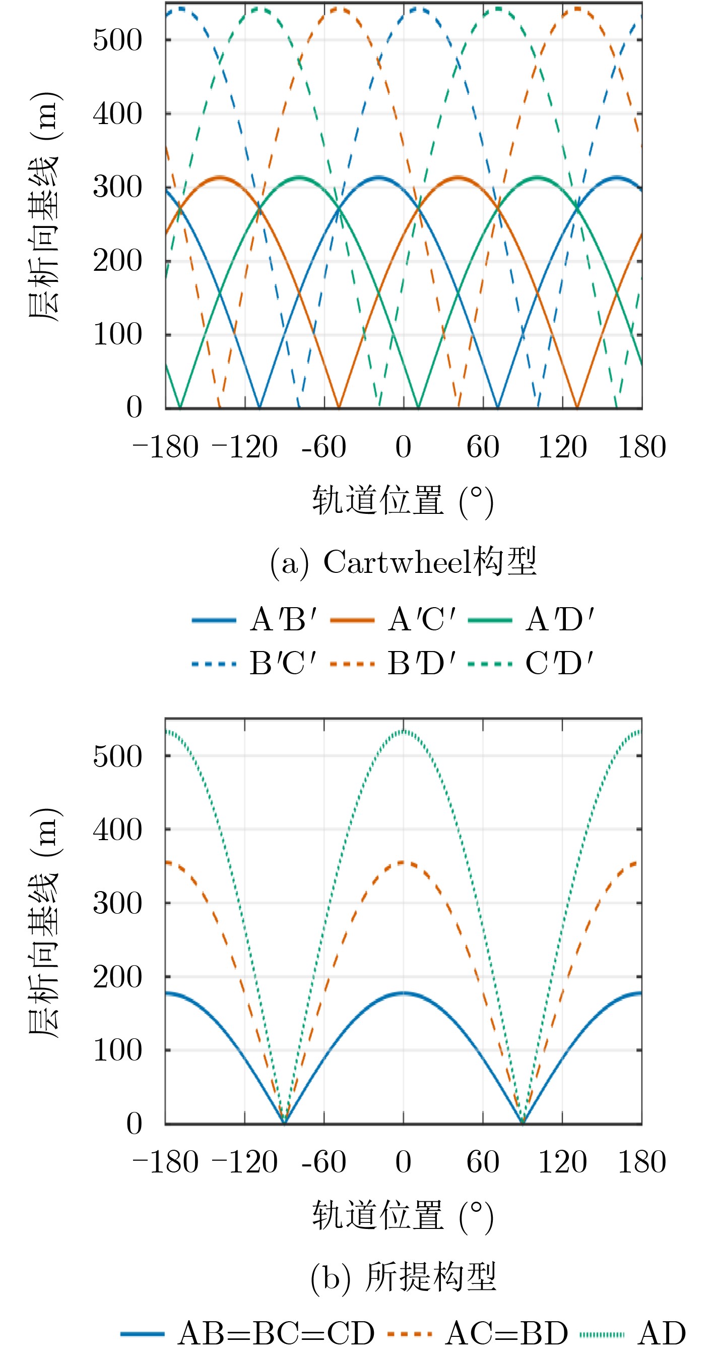
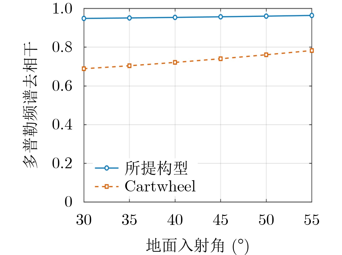
  •   Objective  Three-Dimensional (3D) Synthetic Aperture Radar (SAR) tomography can overcome layover, perspective foreshortening, and shadowing encountered in two-dimensional SAR imaging. It can also resolve multiple scatterers within the same azimuth-range resolution cell in the elevation direction, enabling high-precision 3D imaging of targets. High-resolution and high-precision SAR tomographic imaging requires repeated observations and data accumulation over the same location. Conventional satellite systems must therefore conduct repeated overpasses and frequently adjust their orbits to obtain the required observation geometry, incurring substantial system costs. Even with these measures, temporal decorrelation cannot be eliminated. Distributed satellite formations can obtain simultaneous multi-baseline observations of the same region through coordinated flight of multiple satellites. However, existing distributed satellite formation configurations are not optimized for 3D SAR tomography. This study proposes a formation-design method tailored to tomographic imaging. By appropriately designing satellite orbits, the method establishes a distributed observation array in space and enables high-resolution, high-precision 3D SAR imaging in a single pass. Formation-maintenance strategies are also developed based on the stability of in-orbit configurations, demonstrating the practical engineering value of the proposed method.  Methods  To meet the elevation-direction array-imaging requirements of 3D SAR tomography, a mathematical model relating the three-dimensional baselines of distributed SAR satellites to their relative motion is established. The model is expressed in the Radial-Transverse-Normal (RTN) coordinate system to derive the elevation-direction synthetic aperture, normal baseline, and along-track baseline required for tomographic imaging. This establishes a direct relationship between the three-dimensional baselines and the six orbital elements of the formation satellites, allowing the desired baseline distribution to be achieved by directly designing their orbital parameters. To meet the linear-array observation requirements, two types of multi-satellite formations are designed: a nested-wheel side-by-side formation with vertically aligned satellites and a transverse side-by-side formation with laterally aligned satellites. The satellite trajectories are designed to maintain a linear array at every instant of the orbital period. The resulting spatial baselines satisfy the array-observation requirements of 3D SAR tomography. Formation-configuration divergence is also analyzed through simulations, and corresponding formation-maintenance strategies are proposed, demonstrating the engineering feasibility of the method.  Results and Discussions  A nested-wheel side-by-side multi-satellite formation is designed to generate a vertical-aperture baseline, with the normal baseline set to zero and the arguments of latitude of the main and follower satellites set equal ua=uc. The semi-major axes, eccentricities, and arguments of perigee of the satellites are selected according to the required vertical-aperture baseline length. The argument of latitude is then determined based on the required observation position, ensuring that the maximum radial baseline occurs at the desired position. The resulting maximum radial-baseline amplitude is $ a{e}_{a} $, yielding a vertically aligned linear formation of distributed SAR satellites (Figs. 3 and 4). To generate a normal baseline, a transverse side-by-side multi-satellite formation is designed with the radial baseline set to zero. The eccentricity of the follower satellite ea is set to zero, and the difference in the right ascension of the ascending node Δ$\varOmega $ between the main and follower satellites is selected to achieve the required normal baseline, whose maximum amplitude is $ |{a}_{c}({\varOmega }_{a}-{\varOmega }_{c})\sin {i}_{c}| $. This produces a transversely aligned linear four-satellite formation (Figs. 5 and 6). Both configurations provide stable baselines for linear-array observations and meet the requirements of 3D SAR tomography. Using the nested-wheel side-by-side four-satellite formation as an example, configuration divergence under atmospheric drag is analyzed. Because atmospheric drag causes semi-major-axis decay and the resulting along-track drift, a formation-maintenance strategy is proposed based on the difference between the drift of the centers of the relative-motion ellipses of the two satellite groups. When $ \left| {\varDelta }_{1}-{\varDelta }_{2}\right| \leq {L}_{\max } $, the formation can perform SAR imaging tasks normally; when$ \left| {\varDelta }_{1}-{\varDelta }_{2}\right| \geq {L}_{\max } $, configuration maintenance operations are required. Comparative simulations are conducted to evaluate the 3D SAR tomographic imaging performance of the proposed nested-wheel side-by-side four-satellite formation and a cartwheel formation consisting of a central master satellite and three orbiting auxiliary satellites. For ground-incidence angles of 30°~55°, the coherence coefficient of the proposed configuration is consistently higher than that of the cartwheel configuration. This reduces coherence loss caused by along-track separation between formation satellites, thereby improving 3D imaging accuracy (Fig. 12).  Conclusions  The proposed nested-wheel side-by-side four-satellite formation provides a stable vertical-aperture baseline for 3D SAR tomographic imaging. Its formation-maintenance strategy is straightforward to implement and offers good engineering feasibility. Distributed satellite formations enable multiple observations in a single pass, overcoming the temporal-decorrelation limitation of conventional multi-pass observations and supporting high-resolution, high-precision 3D SAR tomography. The nested-wheel side-by-side and transverse side-by-side configurations provide stable baselines for linear-array observations, with the former designed to generate the vertical-aperture baseline and the latter to generate the normal baseline. Simulation results show that the divergence of the nested-wheel side-by-side formation during coplanar flight is primarily caused by semi-major-axis decay. Formation stability can be maintained by controlling the rate of semi-major-axis decay, and the analytical results agree with the formation simulations. Imaging simulations further demonstrate that the proposed four-satellite formation provides stable tomographic baselines, reduces coherence loss caused by along-track separation between formation satellites, and improves 3D imaging performance. These findings provide a technical reference for the design of next-generation 3D SAR tomography systems.
  • loading
  • [1]
    丁赤飚, 仇晓兰, 吴一戎. 全息合成孔径雷达的概念、体制和方法[J]. 雷达学报, 2020, 9(3): 399–408. doi: 10.12000/JR20063.

    DING Chibiao, QIU Xiaolan, and WU Yirong. Concept, system, and method of holographic synthetic aperture radar[J]. Journal of Radar, 2020, 9(3): 399–408. doi: 10.12000/JR20063.
    [2]
    DING Zegang, ZHAO Jian, WANG Zhen, et al. Multi-master TomoSAR 3-D imaging: Theoretical complement and performance extension[J]. IEEE Transactions on Geoscience and Remote Sensing, 2024, 62: 5218718. doi: 10.1109/TGRS.2024.3433033.
    [3]
    焦润之, 邓嘉, 韩亚权, 等. 3DSARBuSim 1.0: 人造建筑高分辨星载SAR三维成像仿真数据集[J]. 电子与信息学报, 2024, 46(7): 2681–2693. doi: 10.11999/JEIT230882.

    JIAO Runzhi, DENG Jia, HAN Yaquan, et al. 3DSARBuSim 1.0: High-resolution space borne SAR 3D imaging simulation dataset of man-made buildings[J]. Journal of Electronics & Information Technology, 2024, 46(7): 2681–2693. doi: 10.11999/JEIT230882.
    [4]
    姬昂, 裴昊, 张邦杰, 等. 阵列 SAR 高分辨三维成像与点云聚类研究[J]. 电子与信息学报, 2024, 46(5): 2087–2094. doi: 10.11999/JEIT231223.

    JI Ang, PEI Hao, ZHANG Bangjie, et al. Research on High-resolution 3D Imaging and Point Cloud Clustering of Array SAR[J]. Journal of Electronics & Information Technology, 2024, 46(5): 2087–2094. doi: 10.11999/JEIT231223.
    [5]
    李宁, 牛金发, 王玮斌, 等. 复杂运动舰船目标多投影平面 InISAR 三维重建方法[J]. 电子与信息学报, 2026, 48(8): 3649–3660. doi: 10.11999/JEIT251268.

    LI Ning, NIU Jinfa, WANG Weibin, et al. Multi-projection Plane InISAR 3D Reconstruction Method for Complex Moving Ship Targets[J]. Journal of Electronics & Information Technology, 2026, 48(8): 3649–3660. doi: 10.11999/JEIT251268.
    [6]
    KRIEGER G, FIEDLER H, MITTERMAYER J, et al. Analysis of multistatic configurations for spaceborne SAR interferometry[J]. IEE Proceedings-Radar, Sonar and Navigation, 2003, 150(3): 87–96. doi: 10.1049/ip-rsn:20030441.
    [7]
    KRIEGER G, MOREIRA A, FIEDLER H, et al. TanDEM-X: A satellite formation for high-resolution SAR interferometry[J]. IEEE Transactions on Geoscience and Remote Sensing, 2007, 45(11): 3317–3341. doi: 10.1109/TGRS.2007.900693.
    [8]
    ZINK M, MOREIRA A, HAJNSEK I, et al. TanDEM-X: 10 years of formation flying bistatic SAR interferometry[J]. IEEE Journal of Selected Topics in Applied Earth Observations and Remote Sensing, 2021, 14: 3546–3565. doi: 10.1109/JSTARS.2021.3062286.
    [9]
    MOREIRA A, KRIEGER G, HAJNSEK I, et al. Tandem-L: A highly innovative bistatic SAR mission for global observation of dynamic processes on the Earth’s surface[J]. IEEE Geoscience and Remote Sensing Magazine, 2015, 3(2): 8–23. doi: 10.1109/MGRS.2015.2437353.
    [10]
    ZINK M and MOREIRA A. TanDEM-X mission status: The new topography of the Earth takes shape[C]. 2014 IEEE Geoscience and Remote Sensing Symposium, Quebec City, Canada, 2014: 3386–3389. doi: 10.1109/IGARSS.2014.6947207.
    [11]
    杨元喜, 王建荣, 楼良盛, 等. 航天测绘发展现状与展望[J]. 中国空间科学技术, 2022, 42(3): 1–9. doi: 10.16708/j.cnki.1000-758X.2022.0031.

    YANG Yuanxi, WANG Jianrong, LOU Liangsheng, et al. Development status and prospect of satellite-based surveying[J]. Chinese Space Science and Technology, 2022, 42(3): 1–9. doi: 10.16708/j.cnki.1000-758X.2022.0031.
    [12]
    朱泽尧, 赵双明, 张文, 等. 宏图一号分布式车轮编队InSAR卫星高程反演方法[J]. 武汉大学学报: 信息科学版, 2025, 50(8): 1619–1630. doi: 10.13203/j.whugis20240501.

    ZHU Zeyao, ZHAO Shuangming, ZHANG Wen, et al. Elevation inversion method for HT-1 distributed cartwheel InSAR satellite system[J]. Geomatics and Information Science of Wuhan University, 2025, 50(8): 1619–1630. doi: 10.13203/j.whugis20240501.
    [13]
    张双成, 王铭辉, 杨娜, 等. 国产航天宏图一号SAR卫星数据干涉测量重建DEM精度验证与分析[J]. 遥感学报, 2025, 29(5): 1290–1304. doi: 10.11834/jrs.20254548.

    ZHANG Shuangcheng, WANG Minghui, YANG Na, et al. SAR satellite data from domestic PIESAT-1 interferometric reconstruction: DEM accuracy verification and analysis[J]. National Remote Sensing Bulletin, 2025, 29(5): 1290–1304. doi: 10.11834/jrs.20254548.
    [14]
    赵克祥, 毕辉, 张冰尘. 基于快速阈值迭代的SAR层析成像处理方法[J]. 系统工程与电子技术, 2017, 39(5): 1019–1023. doi: 10.3969/j.issn.1001-506X.2017.05.11.

    ZHAO Kexiang, BI Hui, and ZHANG Bingchen. SAR tomography method based on fast iterative shrinkage-thresholding[J]. Systems Engineering and Electronics, 2017, 39(5): 1019–1023. doi: 10.3969/j.issn.1001-506X.2017.05.11.
    [15]
    陈重华, 李楠, 完备, 等. InSAR卫星编队构形保持控制方法[J]. 测绘学报, 2022, 51(12): 2448–2454. doi: 10.11947/j.AGCS.2022.20210382.

    CHEN Chonghua, LI Nan, WAN Bei, et al. Formation-maintaining control strategy for InSAR satellite[J]. Acta Geodaetica et Cartographica Sinica, 2022, 51(12): 2448–2454. doi: 10.11947/j.AGCS.2022.20210382.
  • 加载中

Catalog

    通讯作者: 陈斌, bchen63@163.com
    • 1. 

      沈阳化工大学材料科学与工程学院 沈阳 110142

    1. 本站搜索
    2. 百度学术搜索
    3. 万方数据库搜索
    4. CNKI搜索

    Figures(12)  / Tables(1)

    Article Metrics

    Article views (87) PDF downloads(6) Cited by()
    Proportional views
    Related

    /

    DownLoad:  Full-Size Img  PowerPoint
    Return
    Return