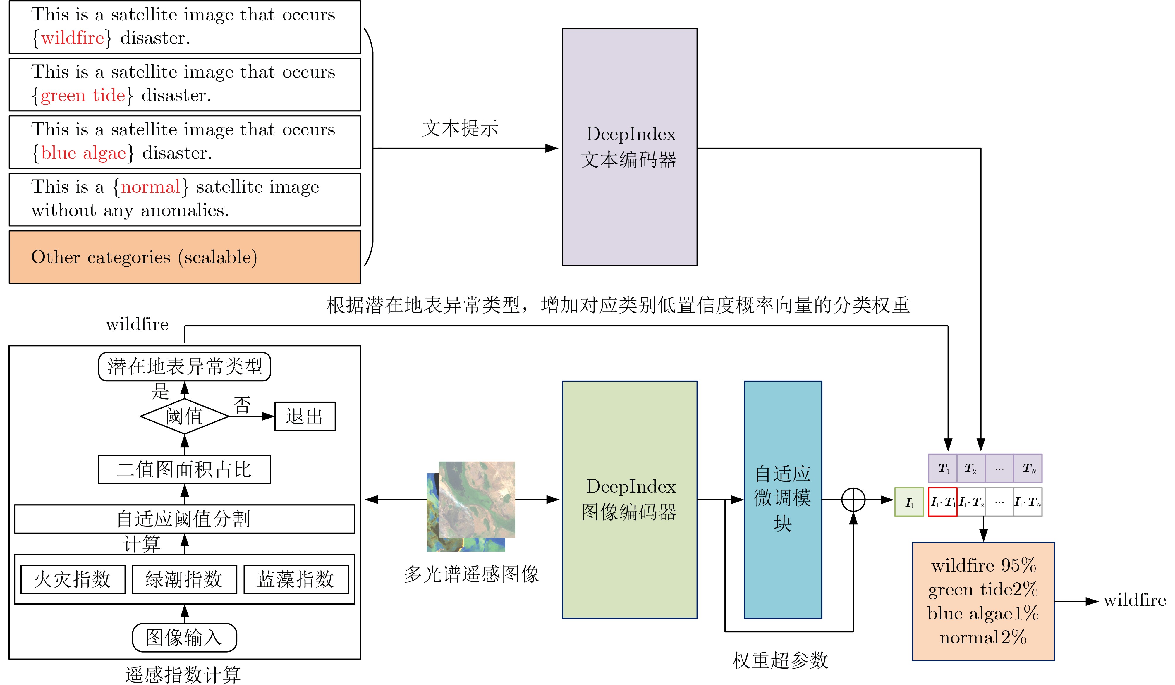
| Citation: | WANG Libo, GAO Zhi, WANG Qiao. A Novel Earth Surface Anomaly Detection Method Based on Collaborative Reasoning of Deep Learning and Remote Sensing Indexes[J]. Journal of Electronics & Information Technology, 2025, 47(6): 1669-1678. doi: 10.11999/JEIT240882

|

| [1] |
王桥. 地表异常遥感探测与即时诊断方法研究框架[J]. 测绘学报, 2022, 51(7): 1141–1152. doi: 10.11947/j.AGCS.2022.20220124.
WANG Qiao. Research framework of remote sensing monitoring and real-time diagnosis of earth surface anomalies[J]. Acta Geodaetica et Cartographica Sinica, 2022, 51(7): 1141–1152. doi: 10.11947/j.AGCS.2022.20220124.
|
| [2] |
WEI Haishuo, JIA Kun, WANG Qiao, et al. Real-time remote sensing detection framework of the earth’s surface anomalies based on a priori knowledge base[J]. International Journal of Applied Earth Observation and Geoinformation, 2023, 122: 103429. doi: 10.1016/j.jag.2023.103429.
|
| [3] |
REN Shoujia, PAN Yaozhong, ZHU Xiufang, et al. A general and simple automated impervious surface mapping approach based on three-dimensional texture features (3DTF) using fine spatial resolution remotely sensed imagery[J]. Science of the Total Environment, 2024, 923: 171181. doi: 10.1016/j.scitotenv.2024.171181.
|
| [4] |
WU Hanyi, ZHAO Chuanwu, ZHU Yu, et al. A multiscale examination of heat health risk inequality and its drivers in mega-urban agglomeration: A case study in the Yangtze River Delta, China[J]. Journal of Cleaner Production, 2024, 458: 142528. doi: 10.1016/j.jclepro.2024.142528.
|
| [5] |
ZHAO Chuanwu, PAN Yaozhong, REN Shoujia, et al. Accurate vegetation destruction detection using remote sensing imagery based on the three-band difference vegetation index (TBDVI) and dual-temporal detection method[J]. International Journal of Applied Earth Observation and Geoinformation, 2024, 127: 103669. doi: 10.1016/j.jag.2024.103669.
|
| [6] |
ZHU Wenquan, YANG Xinyi, LIU Ruoyang, et al. A new feature extraction algorithm for measuring the spatial arrangement of texture Primitives: Distance coding diversity[J]. International Journal of Applied Earth Observation and Geoinformation, 2024, 127: 103698. doi: 10.1016/j.jag.2024.103698.
|
| [7] |
LIU Ruoyang, ZHU Wenquan, and YANG Xinyi. Screening image features of collapsed buildings for operational and rapid remote sensing identification[J]. Remote Sensing, 2023, 15(24): 5747. doi: 10.3390/rs15245747.
|
| [8] |
ROY D P, JIN Yufang, LEWIS P E, et al. Prototyping a global algorithm for systematic fire-affected area mapping using MODIS time series data[J]. Remote Sensing of Environment, 2005, 97(2): 137–162. doi: 10.1016/j.rse.2005.04.007.
|
| [9] |
YANG Fan, GUO Jianhua, TAN Hai, et al. Automated extraction of urban water bodies from ZY-3 multi-spectral imagery[J]. Water, 2017, 9(2): 144. doi: 10.3390/w9020144.
|
| [10] |
FAN Jiahui, YAO Yunjun, TANG Qingxin, et al. A hybrid index for monitoring burned vegetation by combining image texture features with vegetation indices[J]. Remote Sensing, 2024, 16(9): 1539. doi: 10.3390/rs16091539.
|
| [11] |
WEI Haishuo, JIA Kun, WANG Qiao, et al. A remote sensing index for the detection of multi-type water quality anomalies in complex geographical environments[J]. International Journal of Digital Earth, 2024, 17(1): 2313695. doi: 10.1080/17538947.2024.2313695.
|
| [12] |
ZHAO Chuanwu, PAN Yaozhong, WU Hanyi, et al. A novel spectral index for vegetation destruction event detection based on multispectral remote sensing imagery[J]. IEEE Journal of Selected Topics in Applied Earth Observations and Remote Sensing, 2024, 17: 11290–11309. doi: 10.1109/JSTARS.2024.3412737.
|
| [13] |
LECUN Y, BENGIO Y, and HINTON G. Deep learning[J]. Nature, 2015, 521(7553): 436–444. doi: 10.1038/nature14539.
|
| [14] |
JIAO Licheng, HUANG Zhongjian, LIU Xu, et al. Brain-inspired remote sensing interpretation: A comprehensive survey[J]. IEEE Journal of Selected Topics in Applied Earth Observations and Remote Sensing, 2023, 16: 2992–3033. doi: 10.1109/JSTARS.2023.3247455.
|
| [15] |
ZHU Xiaoxiang, TUIA D, MOU Lichao, et al. Deep learning in remote sensing: A comprehensive review and list of resources[J]. IEEE Geoscience and Remote Sensing Magazine, 2017, 5(4): 8–36. doi: 10.1109/MGRS.2017.2762307.
|
| [16] |
WANG Libo, LI Rui, ZHANG Ce, et al. UNetFormer: A UNet-like transformer for efficient semantic segmentation of remote sensing urban scene imagery[J]. ISPRS Journal of Photogrammetry and Remote Sensing, 2022, 190: 196–214. doi: 10.1016/j.isprsjprs.2022.06.008.
|
| [17] |
HONG Danfeng, ZHANG Bing, LI Xuyang, et al. SpectralGPT: Spectral remote sensing foundation model[J]. IEEE Transactions on Pattern Analysis and Machine Intelligence, 2024, 46(8): 5227–5244. doi: 10.1109/TPAMI.2024.3362475.
|
| [18] |
SU Hongjun, WU Zhaoyue, ZHANG Huihui, et al. Hyperspectral anomaly detection: A survey[J]. IEEE Geoscience and Remote Sensing Magazine, 2022, 10(1): 64–90. doi: 10.1109/MGRS.2021.3105440.
|
| [19] |
XU Yichu, ZHANG Lefei, DU Bo, et al. Hyperspectral anomaly detection based on machine learning: An overview[J]. IEEE Journal of Selected Topics in Applied Earth Observations and Remote Sensing, 2022, 15: 3351–3364. doi: 10.1109/JSTARS.2022.3167830.
|
| [20] |
LI Chenyu, ZHANG Bing, HONG Danfeng, et al. LRR-Net: An interpretable deep unfolding network for hyperspectral anomaly detection[J]. IEEE Transactions on Geoscience and Remote Sensing, 2023, 61: 5513412. doi: 10.1109/TGRS.2023.3279834.
|
| [21] |
LI Jingtao, WANG Xinyu, ZHAO Hengwei, et al. Anomaly segmentation for high-resolution remote sensing images based on pixel descriptors[C]. The 37th AAAI Conference on Artificial Intelligence, Washington, USA, 2023: 4426–4434. doi: 10.1609/aaai.v37i4.25563.
|
| [22] |
CHEN Boan, GAO Zhi, LI Ziyao, et al. Hierarchical GNN framework for earth’s surface anomaly detection in single satellite imagery[J]. IEEE Transactions on Geoscience and Remote Sensing, 2024, 62: 5627314. doi: 10.1109/TGRS.2024.3408330.
|
| [23] |
XU Jianming, YAN Kai, FAN Zaiwang, et al. Toward a novel method for general on-orbit earth surface anomaly detection leveraging large vision models and lightweight priors[J]. IEEE Transactions on Geoscience and Remote Sensing, 2024, 62: 4706321. doi: 10.1109/TGRS.2024.3432749.
|
| [24] |
GAO Peng, GENG Shijie, ZHANG Renrui, et al. CLIP-Adapter: Better vision-language models with feature adapters[J]. International Journal of Computer Vision, 2024, 132(2): 581–595. doi: 10.1007/s11263-023-01891-x.
|
| [25] |
RADFORD A, KIM J W, HALLACY C, et al. Learning transferable visual models from natural language supervision[C]. The 38th International Conference on Machine Learning, 2021: 8748–8763.
|
| [26] |
SCHUHMANN C, BEAUMONT R, VENCU R, et al. LAION-5B: An open large-scale dataset for training next generation image-text models[C]. The 36th International Conference on Neural Information Processing Systems, New Orleans, USA, 2022: 1833.
|
| [27] |
DOSOVITSKIY A, BEYER L, KOLESNIKOV A, et al. An image is worth 16x16 words: Transformers for image recognition at scale[C]. 9th International Conference on Learning Representations, Austria, 2021.
|
| [28] |
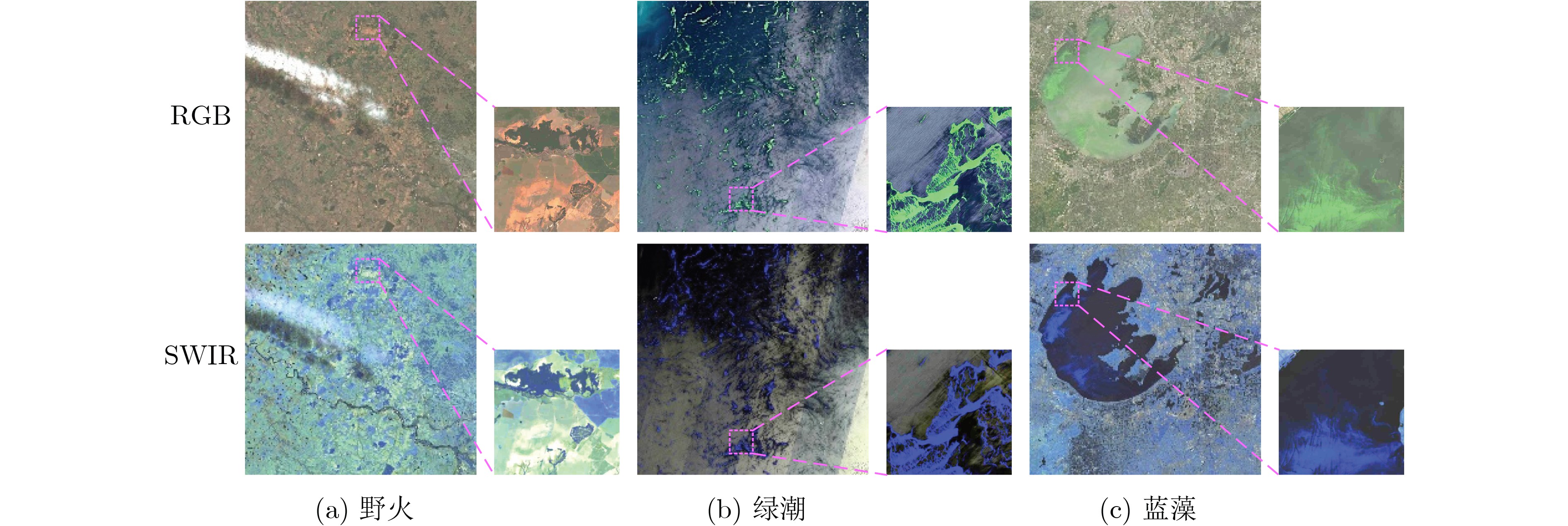
ZHANG Hailong, QIU Zhongfeng, DEVRED E, et al. A simple and effective method for monitoring floating green macroalgae blooms: A case study in the Yellow Sea[J]. Optics Express, 2019, 27(4): 4528–4548. doi: 10.1364/OE.27.004528.
|
| [29] |
HE Kaiming, ZHANG Xiangyu, REN Shaoqing, et al. Deep residual learning for image recognition[C]. 2016 IEEE Conference on Computer Vision and Pattern Recognition (CVPR), Las Vegas, USA, 2016: 770–778. doi: 10.1109/CVPR.2016.90.
|
| [30] |
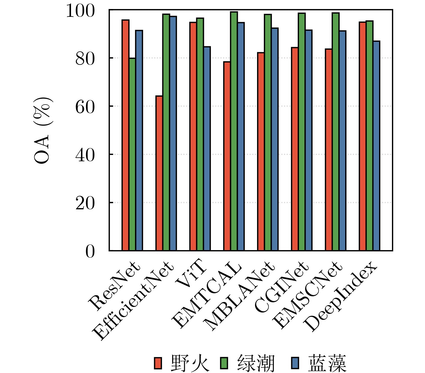
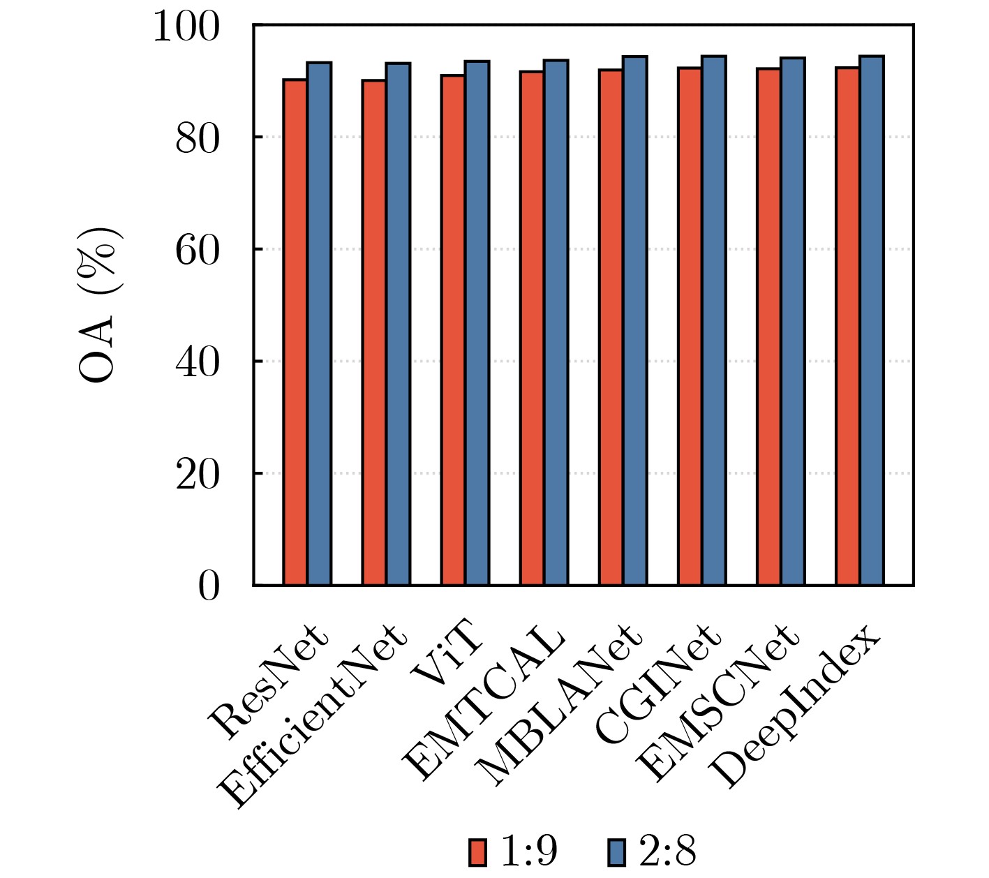
TAN Mingxing and LE Q V. EfficientNet: Rethinking model scaling for convolutional neural networks[C]. The 36th International Conference on Machine Learning, Long Beach, USA, 2019: 6105–6114.
|
| [31] |
TANG Xu, LI Mingteng, MA Jingjing, et al. EMTCAL: Efficient multiscale transformer and cross-level attention learning for remote sensing scene classification[J]. IEEE Transactions on Geoscience and Remote Sensing, 2022, 60: 5626915. doi: 10.1109/TGRS.2022.3194505.
|
| [32] |
CHEN Sibao, WEI Qingsong, WANG Wenzhong, et al. Remote sensing scene classification via multi-branch local attention network[J]. IEEE Transactions on Image Processing, 2022, 31: 99–109. doi: 10.1109/TIP.2021.3127851.
|
| [33] |
ZHAO Yichen, CHEN Yaxiong, XIONG Shengwu, et al. Co-enhanced global-part integration for remote-sensing scene classification[J]. IEEE Transactions on Geoscience and Remote Sensing, 2024, 62: 4702114. doi: 10.1109/TGRS.2024.3367877.
|
| [34] |
ZHAO Yibo, LIU Jianjun, YANG Jinlong, et al. EMSCNet: Efficient multisample contrastive network for remote sensing image scene classification[J]. IEEE Transactions on Geoscience and Remote Sensing, 2023, 61: 5605814. doi: 10.1109/TGRS.2023.3262840.
|
Figures(5) / Tables(5)


 DownLoad: